CBSE Class 12 Geography Sample Paper With Solutions Set 6
[Time Allowed : 3 hrs.] [Max. Marks : 70]
Questions 1-7 (1 Mark), 8-13 (3 Marks), 14-20 (5 Marks), 21 and 22 (Map Question-5 Marks each)
Q.1.Name the most populous and least populous continents.
Ans. Asia is the most populous continent (4.298 billion in 2013) and Oceania (Australia and adjoining island) have the population (only 0.038 billion in 2013).
Q.2. Name the country where practically every farmer is a member of a cooperative society.
Ans. Denmark is the country where practically every farmer is a member of a cooperative society.
Q.3. Which class of cities have the highest percentage of urban population in India?
Ans. Class I cities have the highest percentage of urban population in India.
Q.4. What are the full forms of SFDA and MFDA?
Ans. The full forms of:
•SFDA – Small Farmers Development Agency
MFDA – Marginal Farmers Development Agency
Q.5. What do you mean by regional planning?
Ans. Regional planning is the balanced development of the whole region with a view to reduce economic disparities between the regions.
Q.6. What is meant by balance of trade?
Ans. The difference between import and export values is stated as balance of trade.
Q.7. Name the Asia’s largest slum located in Mumbai.
Ans. The Asia’s largest slum is “Dharavi” located in central Mumbai.
Q.8. State any six sub-fields of social geography.
Ans. The sub-fields of social geography are :
(i)Behavioural geography.
(ii)Geography of social well being.
(iii)Geography of leisure.
(iv)Cultural geography.
(v)Gender geography.
(vi)Historical geography.
(vii)Medical Geography.(any six)
Q.9. What is meant by the literacy rate? Why is there a wide variation in the literacy rates among different countries of the world?
Ans. The term ‘literacy’ rate denotes the percentage of people aged 15 and above who can understand read and write a short, simple statement.
Literacy rates are affected by levels of economic development, urbanization and standard of living, social status of females, availability of educational facilities and the policies of the government. As there are wide variations in the world with respect to these elements, the Literacy rates among different countries of the world vary.
Q.10.Services occur at different levels. Some are geared industry, some to people; and some to both industry and people, e.g. the transport systems. The low-order services, such as grocery shops and laundries, are more common and widespread than the high- order services or more specialized ones like those of accountants, consultants and physicians. Services are provided to individual consumers who can afford to pay for them. For example, the gardener, the launderers and the barber do primarily physical labour. Teachers, lawyers, physicians, musicians and the other perform mental labour. Read the above paragraphs and analyse the following:
(i)How many types of services are there? Name them.
(ii)Write down the features and examples of low order services. What value does it reflect?
Ans. (i) There are two types of services, the name of these services are
(a)Low-order services.
(b)High-order services.
(ii) (a) The services which require physical labour come under the low-order services.
(b)The services performed by gardener, the house maid, the barber, cobbler are the example of low-order services
(c)The low-order services reveal the values like physical-hardship, hard work, sincerity and honesty.
Q.11. Which is the longest trans-continental railway in the world? Write any three characteristics of this trans-continental railway line.
Ans. Trans-Siberian Railways is the longest trans-continental railway in the world. This is the world’s longest railway line which joins St. Petersburg in the west to Vladivostok in the east. It covers a total distance of 9,332 km. Its construction started in 1891. It was completed in 1905 after fourteen years.
Characteristics of Trans-Siberian Railways are as follows :
(i)This railway line was constructed for administrative and military purposes.
(ii)Siberia had benefitted a lot from this railway line, it is very rich in mineral, forest, agricultural and animal resources.
(iii)Products like coal, metals, wood pulp, fur, leather, milk products and wheat are carried from Siberia to European Russia, and most of the finished goods are transported from European Russia to eastern destinations.
(iv)This railway track crosses a number of navigable rivers like Volga, Ob and Amur.
Q.12.Buses merely skirt the periphery. Auto rickshaws cannot go there; Dharavi is part of Central Bombay (Now Mumbai) where three wheelers are banned. Only one main road traverses the slum, the miscalled ‘ninety-foot road’, which has been reduced to less than half of that for most of its length, some of the side alleys and lanes are so narrow that not even a bicycle can pass. The whole neighborhood consists of temporary buildings, two or three storeyed high with rusty iron stairways to the upper part, where a single room is rented by a family, sometimes accommodating twelve or more people; it is a kind of tropical version of the industrial doweling of Victorian London’s East End.
Read the above paragraph and analyse the following:
(i)Name the main road which traverses the slum.
(ii)Name the Asia’s largest slum.
(iii)How many families members are accommodated in a single room? What kind of
value is required?
Ans. (i) Only one main road traverses the slum, the miscalled ‘ninety-foot road’
(ii)Dharavi is the Asia’s largest slum.
(iii)A single room is rented by a family, sometimes accommodating twelve or more people
by a single religious community. .
Value: To follow the family planning programme initiated by the government to reduce
the size of family
Q.13. Explain the problems of slums and urban waste.
Ans. Many problems have arisen due to increasing population and urbanisation. There is shortage of space in towns. The increasing population creates acute shortage of houses, though multi-storeyed buildings are being constructed to solve the problem of houses. The push and pull factors force people to migrate. The migrants construct house on the vacant land, so the slums begin to develop.
The problems of slums are as follows :
•There is dense population in slums.
•There is no facility for electricity, drinking water, drainage, waste disposal, hence congestion in the slums causes many diseases.
The problems of urban waste disposal in the urban Indian cities are :
The uninterrupted flow of immigrants to the urban areas for better job opportunities and better living standards and setting up their habitats on the government land, leads to the development of slums in India.
The four miserable conditions of the residents of slum areas are :
•Slums are devoid of the basic amenities like roads, electricity, sewerage and drinking water.
•Slums are prone to man made hazards (fire etc.) because houses are closely placed.
•The slum workers are engaged in low paid work and high risk prone unorganised sector of the urban economy.
•The people of slums are malnourished and prone to various types of diseases and illness.
•The slum dwellers are uneducated and have low status and the children below 14 years are compelled to work as child labour to support the economic needs of the family.
•The slum dwellers are under the grip of alcoholism, crime, apathy, vandalism, escapism and finally social exclusion due to low economic status.
Q.14. Define the slum settlements. Describe any three characteristics of slum settlements of the world.
Ans. Slums are defined as residential areas that have physically and socially deteriorated.
Three characteristics of slums are :
•They do not offer satisfactory conditions for family life.
•Slums are associated with poor housing condition with inadequate light and fresh air.
•Slums do not have access to drinking water, bathing and toilet facilities.
•These settlements are subjected to fire hazards and are overcrowded. They do have open space for recreational use. Dharavi in Mumbai is Apia’s largest slum.(any three)
Q.15.Why are ports called gateways of international trade? Explain any three facilities provide by them.
Ans. The word ‘port’ is derived from the latin word ‘porta’ which means door or gateway. Infact a port is essentially a gateway from land to sea or from sea to land. Port is a place on the coast which provides facilities such as for docking, loading and unloading and storage facilities for cargo. ‘
A port handles export and import trade of country.
It is well connected with its hinterland by land transport. These land routes are used to transport the goods to a port from where these goods are exported through oceanic routes. Similarly, imports are sent to hinterland of a port.
Infact, a port acts as a point of entery for goods received from foreign countries and a point of exit. Therefore, a port is called a gateway of international trade.
Q.16. Describe the main features of hunting and gathering.
Ans. Hunting and gathering are the oldest occupations of human beings. Earlier all humans lived as hunters and gatherers. Man has been hunting and gathering to satisfy his basic needs. Simple tools like spears, bows, arrows were used for hunting materials available locally to fulfil their basic needs of food and shelter.
Hunting is more prominent in temperate areas, whereas gathering is more prominent in the tropical regions. Hunting is mainly done on different scales :
•For subsistence in polar areas and tropical areas.
•For commercial purposes in temperate areas, e.g., fur bearing animals are hunted in Canada for fur and products are exported. Fishing is done on large scale off the coast of New Foundland, Japan etc, whereas fishing is done for subsistence in Arctic region.
Gathering from the tropical forests is carried out on three scales :
•Small scale subsistence gathering.
•Commercial gathering for import.
•Organised gathering with primary processing.
In the modern times some gathering is market oriented and has become commercial. Gatherers collect valuable plants such as leaves, barks of tree, and medicinal plants and after simple processing sell the products in the market.
Q.17. What are the percentage shares of the rural and urban population in the total population of India, according to the census of 2001? State the four characteristics of rural and urban population.
Ans. The total population of India, as per Census 2001, is 1027 million. 741.66 million (72.22 per cent) population are residing in rural areas and 285.35 million (27.22 per cent) population are living in the urban areas.
The four characteristics of Rural population are :
•The rural population mainly confined to agricultural, animal husbandry and fishing activities etc.
•The rural settlements are unplanned and houses are built of locally available material.
•Rural areas lacking in the basic amenities like telephone, surfaced roads, hospitals, post office, electricity etc.
•Literacy rate is comparatively low and low econpmic status.
Four characteristics of urban population are :
•The urban population mainly engaged in secondary and tertiary activities.
•Urban settlements are planned and well organised.
•The urban population have all the basic modern amenities like telephone, roads, electricity,entertainment, hospitals, education, etc. ,
•The urban population have high literacy rate and also have high economic status.
Q.18. Describe any five factors with examples which affect the location of industries in a particular region of India.
Ans. The location of industries in India is influenced by many factors which are as follows :
(i)Access to Raw Material : Industries using weight losing raw materials are located in source region of the raw materials. Industries using bulk of cheap and heavy raw materials are also located in the regions of raw material. Iron and steel industries, cement industries are located near the raw material to minimise the transport cost.
(ii)Power: Power provides the motive force for machines and therefore, its supply had to be ensured before the location of any industry. Industries like aluminium and synthetic nitrogen manufacturing industries tend to be located near sources of power because they require huge quantum of electricity.
(iii)Market : Market also exerts influence on industrial location in the country. Industrial machinery industries, heavy chemical industries etc., are located near industrial areas because their products are required by other industries of the region. Petroleum refineries are also located near markets.
(iv)Transport and Labour : The means of transport have played an important role in the location and dispersion of industries. Industries tended to concentrate in Mumbai and in around of Kolkata in the early stages because of facilities for import. After the development of railways cotton textile dispersed to the interior part. All major industrial plants are located on the trunk rail lines. Labour cost has also been a consideration but is not a significant factor.
(v)Industrial Policy : In the democratic set up of India, the ultimate decision of selecting location of industries depends on the government policy and public demand. The Bhilai steel plant in Chhattisgarh and the Rourkela iron and steel plant, were set up with the prime objectives of area development.
Q.19. State five characteristics of each of ‘surface water resources’ and ‘groundwater resources’ in India.
Ans. The five characteristics of surface water resources in India are :
(i)The surface water is found in ponds, tanks, rivers, streams and reservoirs,
(ii)Rivers are the major source of water in India. There are 10,360 rivers and their tributaries longer than 1.6 km each spread in our country.
(iii)The mean annual flow is estimated to be 1,869 billion cubic metres.
(iv)Only 690 bmc (32 percent) of the available surface water can be utilised.
(v)The Indus, the Ganga and the Brahamaputra carry nearly 60 percent of the total surface water.
The five characteristics of ground water resources in India are :
(i) The replensishable ground water potential in India is estimated to be 433.9 billion cubic metres.
(ii)Water percolates easily in the alluvial plains hence it has high potential of ground water.
(iii)Uttar Pradesh alone accounts for 19 percent ground water potential.
(iv)About 42 per cent of the ground water potential are confined to the states of Punjab, Haryana, Bihar and West Bengal.
(v)In the peninsular India ground water potential is less or negligible because of rocky land surface.
(vi)Only 37.23 per cent of the available ground water resources have so far been developed in India. (any five)
Q.20. Study the information given in the table below and answer the question that follow:
Indian Railways
Zone-wise income % from passengers and goods
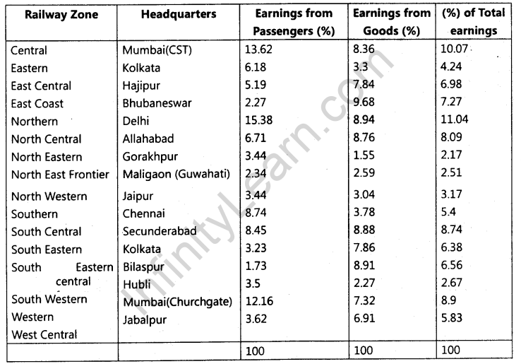
(i)In how many zones is the Indian Railway System divided?
(ii)Which zone shows the highest percentage of earning from passengers?
(iii)Which zone shows highest percentage of earning from goods?
(iv)Name two cities, each of which is the headquarters of two different railway zones.
Ans. (i) Indian Railway System is divided into 16 Zones.
(ii)Northern Zone shows the highest percentage of earning from passengers.
(iii)The East Coast shows highest percentage of earning from goods.
(a)Mumbai CST .
(b)Mumbai Churchgate
Q.21. On the given outline map of the World, following five features are shown. Identify these features and write their correct names on the lines marked near each feature:
(i)Mega City
(ii)Major Sea Port
(iii)Industrial Region of North America
(iv)Major Areas of Nomadic Herding
(v)Major Airport
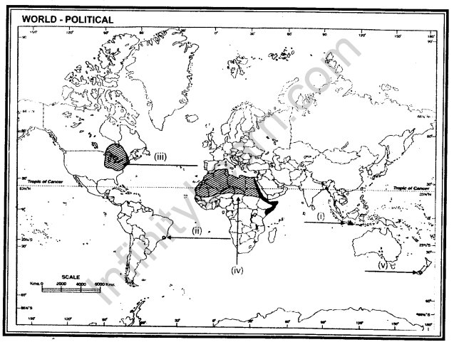
Ans. (i) Jakarta (ii) Rio De Janerio (iii) Great Lakes Regions of North America (iv) North Africa (v) Wellington
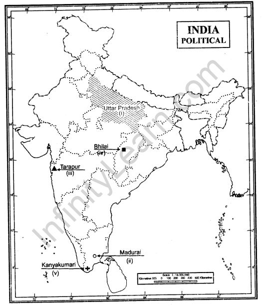
Q.22. On the given outline map of India, locate and label the following with appropriate symbols:
(i)The most populous state
(ii)The southernmost metropolitan city of Tamil Nadu
(iii)Nuclear Power Station Of Maharashtra
(iv)Iron and steel industry of Chhattisgarh ,
(v)Southern Terminal of North- South Corridor
Ans.