
Table of Contents
Discover the amazing beauty of the Sahara Desert, a vast and mysterious expanse in North Africa. This blog goes into depth about the fascinating history, geographical features, and unique cultural tapestry woven by the countries that share this iconic desert’s border.
Discover the secrets of the Sahara as we travel through its varied landscapes, from mesmerizing sand dunes to rocky plateaus, and uncover ancient rock art that tells stories of a time when the Sahara was a much wetter and thriving region.
Join us on a journey through the sands of time as we investigate the Sahara’s geographic location and the historical treasures hidden beneath its arid surface. This blog promises to be your gateway to the extraordinary realm of the Sahara Desert, whether you are a history enthusiast, a geography buff, or simply curious about the wonders of our world.
Sahara Desert Introduction


The Sahara is a desert spanning North Africa, with an area of 9,200,000 square kilometers. It is the largest hot desert in the world and the third-largest desert in the world. The Sahara Desert is only smaller than the deserts of Antarctica and the Arctic.
The name Sahara is derived from the Arabic word for desert in its feminine irregular form. The Sahara Desert is known for its extreme climatic conditions, with scorching daytime temperatures that can exceed 50 degrees Celcius and significantly chilly nights. Rainfall is scarce, and the region is considered hyper-arid, receiving very little precipitation.
The Sahara is so large and bright that it could be detected as a surface feature of Earth by other stars using current technology. The Sahara is mainly a rocky stone plateau; ergs form only a minor part, but many of the sand dunes are over 590 feet high.
Sahara Desert History
People have lived on the desert’s edge for thousands of years, since the end of the last glacial period. Engraved and painted rock art was created in the Central Sahara possibly as early as 10,000 years ago, spanning the Bubaline Period, Kel Essuf Period, Round Head Period, Pastoral Period, Caballine Period, and Cameline Period.
- The Sahara was much wetter back then than it is now. Over 30,000 petroglyphs of river animals such as crocodiles have survived, with half of them discovered in the Tassili n’Ajjer region of southeast Algeria. Dinosaur fossils such as Afrovenator, J.Jobaria, and Ouranosaurus have also been discovered here. The modern Sahara, on the other hand, is devoid of vegetation except in the Nile Valley, a few oases, and the northern highlands, where Mediterranean plants such as the olive tree grow.
- It was long assumed that the region had been like this since around 1600 BCE, when shifts in the Earth’s axis increased temperatures and decreased precipitation, resulting in the abrupt desertification of North Africa about 5,400 years ago.
- Dinosaur fossils, such as Afrovenator and Ouranosaurus, have been discovered in the area.
- The Kiffin culture, which existed between 10,000 and 8,000 years ago, left evidence of skilled hunters living on the shores of a lake during a wetter period. The Tenerians succeeded the Kiffians, leaving distinctive burials and artifacts, but they vanished around 8,000 years ago when the Sahara went dry.
- Uan Muhuggiag, which was inhabited from the sixth millennium BCE to approximately 2700 BCE, revealed a well-preserved mummy of a young boy, providing insights into early burial practices.
- The Nubians, who lived before desertification around 9500 BCE, practiced agriculture and had a complex society, as evidenced by megaliths at Nabta Playa.
- The Sahara had become as dry as it is today by 3400 BCE, limiting human movement. Around 4000 BCE, the Tichitt culture emerged, displaying sophisticated social structures, agriculture, and iron metallurgy.
- The Phoenicians settled along the North African coast and interacted with Berber-speaking people. Around 500 BCE, Greeks arrived and established trading colonies along the Red Sea.
- Around 500 BCE, the Garamantes, an urban civilization, thrived in the heart of the Sahara, building an empire through innovative water management. Their civilization, however, was destroyed due to a lack of water resources.
- Islamic influence expanded in the Sahara from the 7th century onwards, with the Muslim conquest of North Africa. Trans-Saharan trade and a significant slave trade across the desert flourished.
- European colonialism in the 19th century saw France and other powers occupying Sahara regions. By the early 20th century, the trans-Saharan trade declined due to modern transportation.
- Most Saharan states gained independence after World War II. Tuareg rebellions occurred, and Islamist groups like al-Qaeda in the Islamic Maghreb have become prominent.


Sahara Desert Location
The desert covers much of North Africa, excluding the fertile regions on the Mediterranean Sea coast, the Atlas Mountains of the Maghreb, the Nile Valley in Egypt, and the Sudan.
It stretches from the Red Sea in the east and the Mediterranean in the north to the Atlantic Ocean in the west, where the landscape gradually changes from deserts to coastal plains. To the south, it is bounded by the Sahel, a belt of semi-arid tropical savanna around the Niger River valley and the Sudan region of sub-Saharan Africa.
The Sahara can be divided into several regions, including the western Sahara, the central Ahaggar Mountains, the Tibesti Mountains, the Air Mountains, the Tenere Desert, and the Libyan Desert.
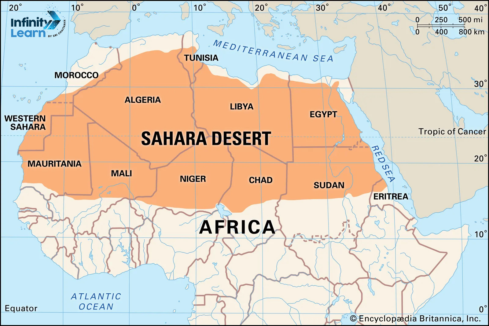
Sahara Desert Map
- The Sahara Desert is found in North Africa, roughly between 20° N and 25° N latitudes and 13° W and 25° E longitudes.
- The northern boundary of the Sahara is generally the transition zone between the desert and the Mediterranean Sea. This transition zone includes coastal areas of countries such as Morocco, Algeria, Tunisia, Libya, and Egypt.
- The western boundary extends into the Atlantic coast of Western Sahara, Mauritania, and parts of Mali.
- The eastern boundary reaches into the Red Sea and the Sinai Peninsula, including parts of Egypt.
- The southern boundary of the Sahara transitions into the Sahel region, a semi-arid zone that lies between the Sahara to the north and the more humid savannas to the south. Countries like Mali, Niger, Chad, Sudan, and South Sudan have areas that are part of the Sahara Desert or are influenced by its climatic conditions.
FAQs on Sahara Desert
Where is the Sahara Desert located?
The Sahara Desert is located in northern Africa and covers over 3,500,000 square miles (9,000,000 square kilometers), or approximately 10% of the continent. The Red Sea borders it on the east, and it stretches west to the Atlantic Ocean.
How many countries are in the desert?
Algeria, Chad, Egypt, Libya, Mauritania, Morocco, Niger, Western Sahara, Sudan, and Tunisia are among the countries that make up the vast desert.
Which ecoregion covers a large area in the Sahara Desert?
The Atlantic Coastal Desert ecoregion spans 39,900 square kilometers along the Atlantic coast in the western Sahara Desert. The North Saharan steppe and woodlands ecoregion extends 1,675,300 square kilometers along the northern edge of the Sahara Desert.
In which country is Sahara Desert?
The Sahara Desert is located in North Africa, spanning countries such as Morocco, Algeria, Chad, Egypt, Libya, Mali, Mauritania, Niger, Western Sahara, Sudan, and Tunisia. It is the largest hot desert in the world, covering an area of 3.6 million square miles. The desert is known for its sand dunes, which can reach up to 180 meters in height
What is the real name of Sahara Desert?
The real name of the Sahara Desert is Al-Sahra, al-Kubra, or the Great Desert in Arabic. The name is derived from the Arabic word Sahra, which means desert.
Is the Sahara desert famous?
Yes, the Sahara Desert is famous for its size, geographical features, and historical significance. It is the world's largest hot desert and covers nearly all of northern Africa. The desert is characterized by its arid climate, sand dunes, and rocky landscapes, which make it a difficult environment for sustaining life.


