
Table of Contents
Introduction
The geomagnetic field, also known as the Earth’s magnetic field, is the magnetic field that extends from the Earth’s interior into space, where it interacts with the solar wind, a stream of charged particles emitted by the Sun. The magnetic field is created by electric currents caused by the motion of convection currents of molten iron and nickel in Earth’s outer core: these convection currents are caused by heat escaping from the core, which is a natural process known as a geodynamo. At its surface, the magnitude of the Earth’s magnetic field ranges from 25 to 65 T. (0.25 to 0.65 gauss). It is approximated by a magnetic dipole field currently tilted at an angle of about 11 degrees with respect to Earth’s rotational axis as if an enormous bar magnet were placed at that angle through the center of Earth. The North geomagnetic pole actually represents the South pole of Earth’s magnetic field, and vice versa (because opposite magnetic poles attract and the north end of a magnet, Points toward Earth’s South magnetic field, i.e., the North geomagnetic pole near the Geographic North Pole, like a compass needle). The North geomagnetic pole was located on Ellesmere Island, Nunavut, Canada, in 2015.
While the North and South magnetic poles are usually near the geographic poles, they move slowly and continuously over geological time scales, but slowly enough for ordinary compasses to remain useful for navigation. However, at irregular intervals of several hundred thousand years, the Earth’s magnetic field reverses and the North and South Magnetic Poles abruptly switch places. These geomagnetic pole reversals leave a record in rocks that paleomagnetism can use to calculate geomagnetic fields in the past. This information is then useful in studying the movements of continents and ocean floors during the plate tectonics process. The magnetosphere is the region of space above the ionosphere defined by the extent of the Earth’s magnetic field. It stretches several tens of thousands of kilometres into space, shielding Earth from charged particles in the solar wind and cosmic rays that would otherwise strip away the upper atmosphere, including the ozone layer that shields the planet from harmful ultraviolet radiation.
Overview
The information about magnetic material from various physics-related articles are available here. Magnetic material of a magnetic field and its general concepts are important topics in physics. Students who want to flourish in physics need to be well known about earth magnetism to get deep knowledge about it to do well on their exams. The definition, working principle, and diagram of the earth magnetic fields which determine the inclination, declination, and dip of the surface are provided here to assist students in effectively understanding the respective topic. Continue to visit our website for additional physics help.
The bulk of solar wind is deflected by the Earth’s magnetic field, which would otherwise erode the ozone layer, which protects the planet from dangerous UV light. Gas becomes trapped in magnetic field bubbles, which are later pulled off by solar winds, which is one process for stripping. Calculations of the loss of carbon dioxide from Mars’ atmosphere due to ion scavenging by the solar wind indicate that the dissipation of Mars’ magnetic field resulted in a near-total loss of its atmosphere. The study of the Earth’s past magnetic field is known as paleomagnetism. The polarity of the Earth’s magnetic field is stored in igneous rocks, thus field reversals can be seen as “stripes” centered on mid-ocean ridges where the seafloor is spreading, while the stability of the geomagnetic poles between reversals allows paleomagnetism to follow the previous continent movement. Magnetostratigraphy, a method of dating rocks and sediments, is also based on reversals. The field also magnetizes the crust, and magnetic anomalies can be used to locate metal ore deposits.


Magnetic element
The components are as follows:
- Declination of magnetic declination (q)
- Magnetic proclivity (d)
- Horizontal element (BH)
Magnetic declination: The small angle between a location’s magnetic axis and geographic axis is defined as magnetic declination at that location.
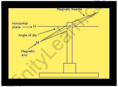
Magnetic Inclination: Magnetic dip, dip angle, or magnetic inclination is the angle formed by the compass needle of a vertically held compass with the horizontal. This angle varies depending on where you are on the Earth’s surface. Positive inclination values indicate that the Earth’s magnetic field is pointing downward, into the Earth, at the point of measurement. The value can be determined using a dip circle, which is a type of instrument.
(1) At the equator, the magnetic field is parallel to the horizon, so the angle of dip is zero.
(2) Because the magnetic field is almost vertical at the poles, the dip will be greatest here.
Horizontal component: It is the component of the earth’s magnetic field that runs horizontally. So the angle of dip is the angle formed by the earth’s magnetic field, denoted by B, and the horizontal component, denoted by BH.
Magnetic Inclination
The magnetic inclination is the angle at which the geomagnetic field is tilted with respect to the earth’s surface. Magnetic inclination ranges from 90 degrees perpendicular to the surface at the magnetic poles to 0 degrees perpendicular to the surface at the magnetic equator. Animals that use the geomagnetic field for navigation rely on the alignment and size of the angle of inclination. Animals that have been studied do not appear to use the magnetic field’s N/S polarisation to determine the direction of the poles. Instead of N/S polarisation, they use the magnetic field’s angle of inclination. The acute angle formed by the magnetic field at the earth’s surface in the northern hemisphere points towards the North Magnetic Pole. In the Southern Hemisphere, the opposite is true. Although the animals cannot distinguish between North and South, they can distinguish between higher and lower latitudes. In addition, the magnitude of the angle with respect to the ground gives a rough indication of latitude. For example, the angle of inclination in the region of Toronto, Ontario, is approximately 72 24′ and 64 0′ in the region of Atlanta, Georgia.
The magnetic inclination is also referred to as the angle of dip. It is the angle formed by the earth’s horizontal plane. The magnetic equator has a dip angle of 0°, while the magnetic poles have a dip angle of 90°.
Theory of Earth’s Magnetism:
There is one theory that explains why the earth’s magnetism exists:
Dynamo effect: The presence of metallic fluids in both the outer and inner cores causes the earth to generate its own magnetic field lines. The outer core is made up of molten iron, while the inner core is made up of solidified elements.
The earth’s core is thought to be made of fluid metal that surrounds a solid inner core that most likely contains a source of heat to drive convection, but it is currently impossible to distinguish between different types of convective motion in the fluid core. The types under consideration are distinguished by radial flow streams and a tendency for the fluid to rotate more rapidly near the axis to conserve angular momentum during circulation. Though the actual flow may be quite complicated, proposed mechanisms for generating a terrestrial magnetic field are considered for some oversimplified flow patterns in an attempt to indicate which flow features may provide the most important possibilities for field generation.
The generating mechanisms discussed include two induction theories, the dynamo theory of Elsasser and Bullard, which is discussed extensively in terms of velocity-current systems represented by elaborate models and in hydromagnetic terms, and the “twisted-kink” theory of Alvèn, which is discussed only hydro magnetically. Each of these theories is based on amplifying an initial stray magnetic field until it dissipates all available energy, and is thus analogous to a conventional electrical generator but without a ferromagnetic core. Other mechanisms discussed are based on either the thermoelectric effect with junctions at the core-mantle interface or a combination of thermoelectric and Hall effects in the core and mantle.


Magnetic Declination
Magnetic declination is defined as the angle on the horizontal plane between magnetic north and true north, which is not constant and changes depending on the position on the earth’s surface and time. Magnetic declination, also known as magnetic variation, is represented by the Greek letter. The declination is positive when the magnetic north is east of the true north and negative when the magnetic north is west of the true north.
The terms isogonic lines (when the lines along the declination are constant) and agonic lines are also used (when the lines along the declination are zero)
The declination calculator: A declination calculator is a simple tool for calculating the declination of any location on the planet. The declination of a given location is calculated using magnetic reference field models and the year, latitude, and longitude of a given location. According to a magnetic declination chart:
A magnetic declination chart is a map that depicts the Earth’s magnetic fields. Using a compass: True, magnetic, and compass bearings are the three types of bearings. A compass can be used to calculate declination because it is one of the compass’s errors, along with magnetic variation.
The difference between the True Meridians and the Magnetic Meridians is defined as magnetic declination. This difference reflects the earth’s magnetic field’s tilt with respect to its axis of rotation. Because the magnetic poles and the axis of rotation do not exactly coincide, compass needles do not indicate true North at most northern hemisphere locations, or true South at most southern hemisphere locations.
Most Topographic Maps have a pair of arrows in the lower left border that looks like clock hands and indicate the difference between geographic N and magnetic N for the center of the area shown.
Aeronautical charts, which are available at or near local airports where flight lessons are offered, provide a more complete picture of magnetic declination. Isogonic lines are lines of equal magnetic declination shown on the charts.
The number of degrees east or west that the magnetic bearing deviates from the true bearing is labelled on the isogonic lines. An isogonic line labelled 8 E indicates that a compass bearing taken near the isogonic line will be rotated 8 counterclockwise of the true bearing.
Magnetic Bearings are converted to True Bearings by adding easterly declination and subtracting westerly declination. The compass bearing in our example is 222, the declination (variation) is 8 E, and the true bearing is 222 + 8 = 230.
Also read: Earth’s Magnetic Field
FAQs
What Is Magnetic Declination and Why Is It Important?
Magnetic declination is an important consideration when planning your trip. A compass always indicates the direction of magnetic power (which joins on what are known as the magnetic poles). The declination is the angle formed by the power direction and bearing of the geographic North Pole. Declination is measured in degrees and minutes east or west to indicate the direction of the magnetic field. If a compass at your location shows true north to the right, it is positive declination or east, and if it shows true north to the left, it is negative declination or west, in degrees and minutes.
Where is the 90-degree angle of dip?
The dip angle varies between -90 degrees at the North Magnetic Pole and +90 degrees at the South Magnetic Pole. Isoclinic lines are the contour lines along which the dip at the Earth's surface is measured. The magnetic equator, also known as the aclinic line, is the locus of points with a zero dip.
What is the purpose of the dip angle?
The dip angle, also known as the magnetic dip, is the angle formed by the earth's magnetic field with the horizontal at any given geographical location. The dip angle is used to both measure and correct the magnetic compass error. It is also useful in the fields of geology and mapping.
