Table of Contents
Introduction
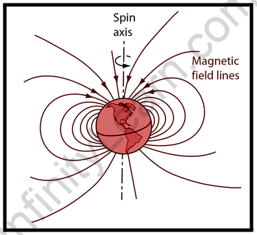
The geomagnetic field, also known as the Earth’s magnetic field, is the magnetic field that extends from the Earth’s interior into space, where it interacts with the solar wind, a stream of charged particles emitted by the Sun. The magnetic field is created by electric currents caused by the motion of convection currents of molten iron and nickel in Earth’s outer core: these convection currents are caused by heat escaping from the core, which is a natural process known as a geodynamo. At its surface, the magnitude of the Earth’s magnetic field ranges from 25 to 65 T. (0.25 to 0.65 gauss). It is approximated by a magnetic dipole field currently tilted at an angle of about 11 degrees with respect to Earth’s rotational axis as if an enormous bar magnet were placed at that angle through the centre of Earth. The North geomagnetic pole actually represents the South pole of Earth’s magnetic field, and vice versa (because opposite magnetic poles attract and the north end of a magnet, Points toward Earth’s South magnetic field, i.e., the North geomagnetic pole near the Geographic North Pole, like a compass needle). The North geomagnetic pole was located on Ellesmere Island, Nunavut, Canada, in 2015.
While the North and South magnetic poles are usually near the geographic poles, they move slowly and continuously over geological time scales, but slowly enough for ordinary compasses to remain useful for navigation. However, at irregular intervals of several hundred thousand years, the Earth’s magnetic field reverses and the North and South Magnetic Poles abruptly switch places. These geomagnetic pole reversals leave a record in rocks that paleomagnetism can use to calculate geomagnetic fields in the past. This information is then useful in studying the movements of continents and ocean floors during the plate tectonics process. The magnetosphere is the region of space above the ionosphere defined by the extent of the Earth’s magnetic field. It stretches several tens of thousands of kilometres into space, shielding Earth from charged particles in the solar wind and cosmic rays that would otherwise strip away the upper atmosphere, including the ozone layer that shields the planet from harmful ultraviolet radiation.
Overview
The bulk of solar wind is deflected by the Earth’s magnetic field, which would otherwise erode the ozone layer, which protects the planet from dangerous UV light. Gas becomes trapped in magnetic field bubbles, which are later pulled off by solar winds, which is one process for stripping. Calculations of the loss of carbon dioxide from Mars’ atmosphere due to ion scavenging by the solar wind indicate that the dissipation of Mars’ magnetic field resulted in a near-total loss of its atmosphere. The study of the Earth’s past magnetic field is known as paleomagnetism. The polarity of the Earth’s magnetic field is stored in igneous rocks, thus field reversals can be seen as “stripes” centred on mid-ocean ridges where the seafloor is spreading, while the stability of the geomagnetic poles between reversals allows paleomagnetism to follow the previous continent movement. Magnetostratigraphy, a method of dating rocks and sediments, is also based on reversals. The field also magnetizes the crust, and magnetic anomalies can be used to locate metal ore deposits.
If you’ve ever used a compass (either a traditional mechanical one or one built into your smartphone), you’ll know that it always points north. If you hang a refrigerator magnet from the ceiling, it will also point north. This implies that there is a magnetic field all around us that is generated by the earth beneath your feet! As we know, the presence of a magnetic field acts as a protective shield around the Earth, repelling and trapping charged particles from the Sun. Tell us about the Earth’s magnetic field in detail in this article.


Earth’s magnetic field
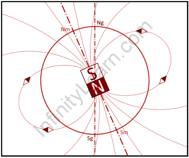
The Earth’s magnetic field (and surface magnetic field) is roughly a magnetic dipole, with the magnetic field S pole near the geographic north pole (see Magnetic North Pole) and the magnetic field N pole near the geographic south pole (see Magnetic South Pole). This allows the compass to be used for navigation. The field’s origin can be explained by dynamo theory.
A magnetic field can extend indefinitely, though its strength diminishes with distance from its source. The Earth’s magnetosphere is formed by the Earth’s magnetic field, also known as the geomagnetic field, which extends several tens of thousands of kilometres into space.
According to a paleomagnetic study of Australian red dacite and pillow basalt, the magnetic field is at least 3.5 billion years old.
The solar wind is responsible for the overall shape of Earth’s magnetosphere, and changes in its speed, density, direction, and entrained magnetic field have a significant impact on Earth’s local space environment.
The levels of ionizing radiation and radio interference, for example, can vary by hundreds to thousands of times; and the shape and location of the magnetopause and bow shock wave upstream of it can change by several Earth radii, exposing geosynchronous satellites to direct solar wind. These phenomena are referred to as space weather.
The mechanism of atmospheric stripping is caused by gas becoming trapped in magnetic field bubbles, which are then ripped off by solar winds. Variations in magnetic field strength have been linked to changes in rainfall in the tropics.
Theory of Earth’s Magnetism
There is one theory that explains why the earth’s magnetism exists:
Dynamo effect: The presence of metallic fluids in both the outer and inner cores causes the earth to generate its own magnetic field lines. The outer core is made up of molten iron, while the inner core is made up of solidified elements.
The earth’s core is thought to be made of fluid metal that surrounds a solid inner core that most likely contains a source of heat to drive convection, but it is currently impossible to distinguish between different types of convective motion in the fluid core. The types under consideration are distinguished by radial flow streams and a tendency for the fluid to rotate more rapidly near the axis to conserve angular momentum during circulation.
Though the actual flow may be quite complicated, proposed mechanisms for generating a terrestrial magnetic field are considered for some oversimplified flow patterns in an attempt to indicate which flow features may provide the most important possibilities for field generation.
Magnetic Declination
Magnetic declination is defined as the angle on the horizontal plane between magnetic north and true north, which is not constant and changes depending on the position on the earth’s surface and time. Magnetic declination, also known as magnetic variation, is represented by the Greek letter. The declination is positive when the magnetic north is east of the true north and negative when the magnetic north is west of the true north.
The terms isogonic lines (when the lines along the declination are constant) and agonic lines are also used (when the lines along the declination are zero)
The declination calculator: A declination calculator is a simple tool for calculating the declination of any location on the planet. The declination of a given location is calculated using magnetic reference field models and the year, latitude, and longitude of a given location. According to a magnetic declination chart:
A magnetic declination chart is a map that depicts the Earth’s magnetic fields. Using a compass: True, magnetic, and compass bearings are the three types of bearings. A compass can be used to calculate declination because it is one of the compass’s errors, along with magnetic variation.


Magnetic Inclination
The magnetic dip is caused by a magnet’s proclivity to align itself with magnetic field lines. The northern end of a compass needle will point downward because the planet’s magnetic field lines are not parallel to the surface. That is, in the northern hemisphere, there is a positive dip or upward trend, whereas, in the southern hemisphere, there is a downward trend.
The dip ranges from -90° at the North Magnetic Pole to +90° at the South Magnetic Pole. Isoclinic lines are contour lines along which the dip measured at the planet’s surface is equal. The magnetic equator, also known as the aclinic line, is a point locus with a zero dip. The dip angle, also known as a magnetic dip or magnetic inclination, is the angle formed by our planet’s magnetic field lines with respect to the horizontal.
The angle of dip varies from point to point on the earth’s surface and provides information about the movement of the magnetic field. The phenomenon is especially important in aviation because it causes the airplane’s compass to give incorrect readings during banked turns and airspeed changes. The latter errors typically occur as a result of the compass card tilting on its mount while under acceleration.
Also read: Important Topic of Physics: Magnetic Element
FAQs
Is the Earth's magnetic field different in different places?
Yes, the magnetic field varies depending on where you are. The magnetic field is affected by both location and time. Satellites and approximately 200 operational magnetic observatories around the world, as well as several more temporary sites, are used to measure the distribution of the magnetic field.
Has the earth's magnetic field changed in recent years?
The magnetic field of the Earth is slowly changing and appears to have changed throughout its existence. When tectonic plates form along oceanic ridges, the magnetic field that exists is imprinted on the rock as it cools below 700 degrees Celsius. The slowly moving plates act as a tape recorder, recording information about the strength and direction of previous magnetic fields.
What is the purpose of the dip angle?
The dip angle, also known as the magnetic dip, is the angle formed by the earth's magnetic field with the horizontal at any given geographical location. The dip angle is used to both measure and correct the magnetic compass error. It is also useful in the fields of geology and mapping.
