
Table of Contents
India’s political map is complex and fascinating, reflecting the country’s rich cultural heritage and diverse geography. The nation is divided into 28 states and 9 union territories, each with a unique identity and traditions.
The states are the primary administrative units of India, while the union territories are centrally administered territories. Some of the states are further divided into smaller administrative units called districts.
The political map of India has been evolving, with the creation of new states and union territories to reflect the country’s changing demographics and political landscape. The latest significant change was the bifurcation of Jammu and Kashmir into two separate union territories in 2019.
India’s political map is a dynamic and ever-changing representation of the country’s rich history and diverse culture. It is a reminder of the nation’s long and complex journey toward unity and democracy.
Change in India’s Political Map and New Unions. As of October 31, 2019, the state of Jammu and Kashmir has been officially divided into two Union Territories (UTs): Jammu & Kashmir and Ladakh. This change is necessary for UPSC exam aspirants to be aware of.
Steps to Download the Official India Political Map?


Follow the steps mentioned below to download the official Political Map of India by visiting the Survey of India website –
- Step 1: Open Google Chrome or your preferred web browser and navigate to the Survey of India website: @https://surveyofindia.gov.in/pages/political-map-of-india
- Step 2: Locate the “Download” button – Look for a prominent “Download” button, typically positioned near the top or right side of the page.
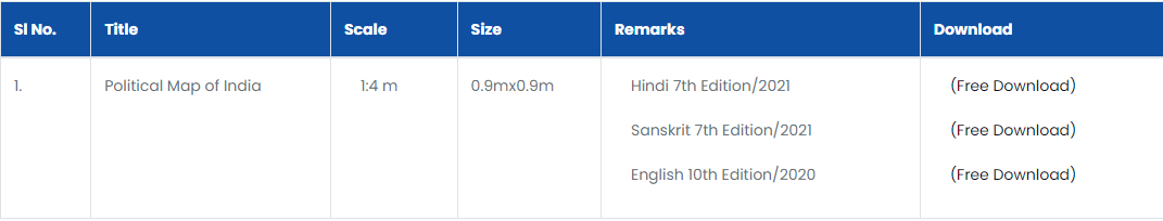
- Step 3: Choose the desired map language – You can download the political map of India either in Hindi, Sanskrit and English. Latest edition is mentioned below –
- Hindi 7th Edition/2021
- Sanskrit 7th Edition/2021
- English 10th Edition/2020
Choose the desired map language.
- Step 4: Select the download location – Decide where to save the downloaded map file. You can save it directly to your desktop, Downloads folder, or any other preferred location.
- Step 5: Confirm the download – Once you’ve selected the download location, confirm the download by clicking the “Download” or “Save” button. The download process should begin automatically.
- Step 6: Wait for the download to complete – The download time will depend on your internet speed and chosen map resolution. Once the download is complete, you should see a notification or a pop-up window indicating the file has been downloaded.
- Step 7: Open the downloaded map file – Locate it (usually in the format .jpg or .png) and double-click on it to open it in your default image viewer. You can now view the political map of India in detail.
- Step 8: Print the map (optional) – If you need a physical copy of the map, you can print it using your printer. Most image viewers provide a print option or menu.
14 Other Types of Maps of India
You can also download the following maps other than the political map of India –
- Physical Map Of India
- Road Map of India
- Railway Map Of India
- India and Adjacent Countries
- World Map
- State Maps
- Guide Maps
- Tourist Maps
- Educational Map Series Outline
- Map of India
- Miscellaneous Maps
- Antique Maps
- District Planning Map
- Series Aeronautical Charts and Maps
The aforementioned maps are also available to download on the official website of Survey of India.


India Political Map – List of States and Union Territories of India
India’s administrative structure comprises 28 states and 9 union territories, each with distinct identity and governance. States, the primary administrative units, enjoy greater autonomy, while union territories of India are centrally administered.
From the bustling metropolises like Maharashtra and Tamil Nadu to the serene landscapes of Himachal Pradesh and Sikkim, India’s states showcase a remarkable diversity of cultures, languages, and traditions. Union territories, such as Andaman and Nicobar Islands and Puducherry, add to the nation’s administrative tapestry, each with its unique identity and governance structure.
Check out the complete list of states and union territories of India below –
| State | Capital | Area (sq km) | Population (in crore) |
| Andhra Pradesh | Amaravati, Hyderabad (till 31st October 2023) | 160,205 | 54.37 |
| Arunachal Pradesh | Itanagar | 83,743 | 1.38 |
| Assam | Dispur | 78,466 | 35.28 |
| Bihar | Patna | 94,163 | 12.58 |
| Chhattisgarh | Raipur | 135,199 | 25.74 |
| Goa | Panaji | 3,702 | 1.44 |
| Gujarat | Gandhinagar | 196,024 | 60.43 |
| Haryana | Chandigarh | 44,212 | 2.59 |
| Himachal Pradesh | Shimla | 55,370 | 7.60 |
| Jammu and Kashmir | Jammu | 222,236 | 13.18 |
| Karnataka | Bengaluru | 191,791 | 64.13 |
| Kerala | Thiruvananthapuram | 38,863 | 3.56 |
| Madhya Pradesh | Bhopal | 308,000 | 72.61 |
| Maharashtra | Mumbai | 307,713 | 124.10 |
| Manipur | Imphal | 22,986 | 2.35 |
| Meghalaya | Shillong | 22,429 | 2.69 |
| Mizoram | Aizawl | 21,081 | 1.15 |
| Nagaland | Kohima | 16,579 | 1.96 |
| Odisha | Bhubaneswar | 155,707 | 43.71 |
| Puducherry | Puducherry | 535 | 0.19 |
| Punjab | Chandigarh | 50,362 | 2.78 |
| Rajasthan | Jaipur | 342,239 | 69.46 |
| Sikkim | Gangtok | 7,096 | 0.66 |
| Tamil Nadu | Chennai | 130,057 | 72.13 |
| Telangana | Hyderabad | 114,844 | 35.51 |
| Tripura | Agartala | 10,486 | 4.03 |
| Uttar Pradesh | Lucknow | 240,933 | 238.70 |
| Uttarakhand | Dehradun | 53,483 | 1.01 |
| West Bengal | Kolkata | 88,752 | 91.36 |
| Andaman and Nicobar Islands | Port Blair | 32,192 | 0.38 |
| Dadra and Nagar Haveli | Silvassa | 491 | 0.60 |
| Daman and Diu | Daman | 1,357 | 0.15 |
| Ladakh | Leh | 57,227 | 0.74 |
FAQ’s on India Political Map
How is the Indian political map?
India's political map is a dynamic representation of the country's administrative divisions, comprising 28 states and 9 union territories. It reflects India's rich cultural diversity and evolving political landscape.
What is the political state of India?
India is a federal republic with a parliamentary system of government. The President heads the state, while the Prime Minister heads the government. India has a multi-party system and a vibrant democracy.
What are the political zones of India?
India is broadly divided into six political zones: North India, South India, East India, West India, Northeast India, and Central India. These zones reflect the country's geographical and cultural diversity.
How many union territories are in India on the political map?
India has 9 union territories, which are centrally administered areas. They are: the Andaman and Nicobar Islands, Dadra and Nagar Haveli, Daman and Diu, Jammu and Kashmir, Ladakh, Puducherry, Chandigarh, NCR Delhi, and Goa.


