
CBSE Class 12 Geography Sample Paper With Solutions Set 18
[Time Allowed : 3 hrs.] [Max. Marks : 70]
Questions 1-7 (1 Mark), 8-13 (3 Marks), 14-20 (5 Marks), 21 and 22 (Map Question-5 Marks each)
Q.1.Define human settlements.
Q.2. Name the headquarters of North Central Railway Zone.
Q.3. Write down the name of any two natural sources of pollutants.
Q.4. Singareni collieries, the country’s premier coal production company, still uses canaries to detect the presence of deadly carbon monoxide in underground mines. Why still they have faith on traditional method.
Q.5. Name the famous pipeline transport of India.
Q.6. Which state of India has the top rank in the “Human Development Index”?
Q.7. How is the cropping intensity calculated in India?
Q.8. How is the knowledge of nature important in developing technology. Explain with suitable examples.
Q.9.The lack of formal credit facilities , in many parts of India farmers are committing suicides, what kind of values are required to check on such type of activities.
Q.10. Study the diagram showing the location of a major steel plant given below and answer the questions that follow:
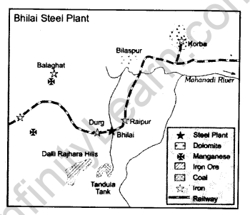
10.1 Identify the steel plant and write down its name.
10.2 Name the source of limestone for this plant.
10.3 Name’the source of coal for this plant.
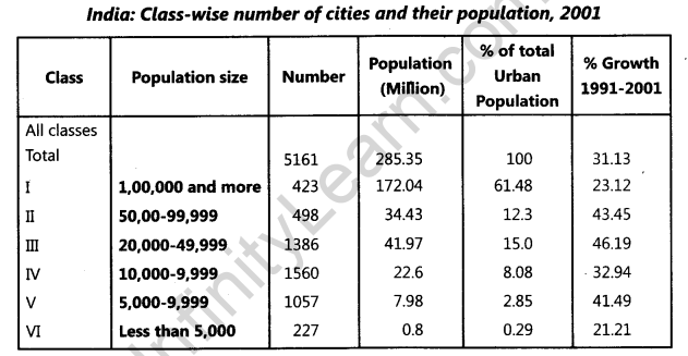
Q.11. Study the table given below and answer the following question:
Q.12. What is mixed farming? Write down four main features of the mixed farming.
Q.13.Slave trade was one of the most lucrative business in Europe, but why it came to an end after seventeenth century. Justify your answer with examples.
Q.14. Explain the types of rural settlement on the basis of forms or shape and also draw the settlement pattern.
Q.15. Name the vital man-made shipping canal, which connects Atlantic Ocean to the Pacific Ocean. State any four main features of this canal.
Q.16. Describe any five features of the occupational structure of the population in India.
Q.17. What are the causes of deterioration of water quality in India? How can we conserve our water resources ? Explain any three points.
Q.18. Why is agricultural productivity still very low in India? Write down any three main reasons.
Q.19. The air transport is one of the most convenient means of transport in the north-eastern India. Justify your answer with any five reasons.
Q.20. Why there is growing importance of Tourism. Describe four factors responsible for tourist attractions.
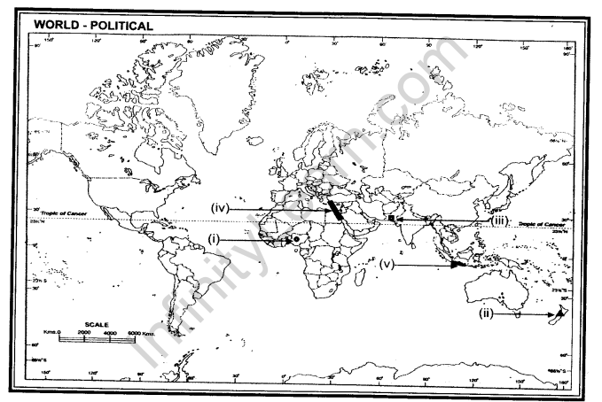
Q.21. In the given political outline map of the World, following five features are shown. Identify
these features and write their correct names on the lines marked near each feature:
(i)Mega city.
(ii)A major sea-port
(iii)A major airport
(iv)Shipping canal
(v)Areas of primitive subsistence agriculture.
Q.22. On the political Outline map of India, locate and label the following with appropriate symbols:
(i)A tidal sea-port of Gujarat.
(ii)Iron and steel plant of Odisha.
(iii)State having the lowest growth rate.
(iv)Northernmost international airport.
(v)An oil refinery of Uttar Pradesh.
