
| Board | CBSE |
| Textbook | NCERT |
| Class | Class 10 |
| Subject | Social Science History |
| Chapter | Chapter 4 |
| Chapter Name | The Making of Global World |
| Number of Questions Solved | 6 |
| Category | Map Work Skills |
Class 10 History Map Work Chapter 4 The Making of Global World
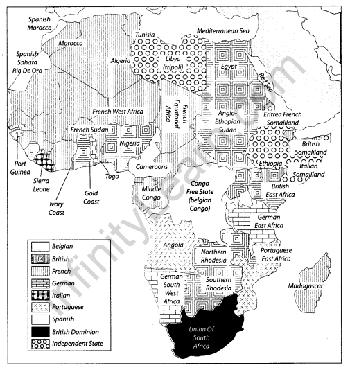
Colonial Africa at the End of 19th Century
This map shows the areas Controlled by European Colonial powers on the African Continent in the 19th Century.
17th Century Trade Routes – India and the World
This map shows the trade routes between India and the World during the 17th Century

Question 1.
Locate and label the following items on the given map with appropriate symbols.
1. Egypt
2. Madagascar
3. Sierra Leone
4. Mediterranean sea

Answer

Question 2.
Features are marked by numbers in the given map of Africa. Identify these features with the help of the following information and write their correct names on the lines marked in the map.
1. British Dominion
2. Portuguese Colony

Answer
Map 6
1. Union of South Africa
2. Angola

Question 3.
Locate and label the following items on the given map with appropriate symbols.
1. Any two port cities of India
2. A trade route between India and China
3. A trade Route between India and Africa

Answer

Question 4.
Locate and label the following items on the given map with appropriate symbols.
1. Red sea
2. Batavia
3. Alexandria

Answer

Question 5.
Features are marked by numbers in the given map of Africa. Identify these features with the help of the following information and write their correct names on the lines marked in the map.
1. An Independent state
2. Spanish Colony
3. Belgian colony

Answer
1. Ethiopia
2. Cameroons

Question 6.
Locate and label the following items on the given map with appropriate symbols.
1. Persian Gulf
2. Macha
3. Mombasa
4. Bangkok
Answer

We hope the given CBSE Class 10 History Map Work Chapter 4 The Making of Global World will help you. If you have any query regarding NCERT Class 10 History Map Work Chapter 4 The Making of Global World, drop a comment below and we will get back to you at the earliest.
