
Table of Contents
Districts of Bangladesh: Bangladesh is a South Asian country known for its rich culture, diverse landscapes, and vibrant history. Administratively, Bangladesh is divided into 64 districts, also known as “zilas” in Bengali. These districts serve as the primary administrative units, each with its own unique characteristics and contributions to the nation’s development.
Bangladesh


Bangladesh, officially known as the People’s Republic of Bangladesh, is a vibrant country in South Asia. It gained independence from Pakistan in 1971 after a significant liberation struggle. The capital city, Dhaka, serves as the political and economic hub of the nation. Bangladesh is home to a diverse population, with the majority being Bengali Muslims, and it boasts a rich cultural heritage.
In recent years, the country has faced various challenges, including the Bangladesh ISKCON temple attack, which highlighted issues of religious tolerance. The political landscape has also been shaped by figures like Khaleda Zia, a prominent leader and former Prime Minister. Additionally, Veena Sikri has played a notable role in strengthening India-Bangladesh relations through her diplomatic efforts. Overall, Bangladesh continues to evolve, balancing its rich traditions with modern aspirations.
How Many Districts in Bangladesh?
As of 2025, there are 64 districts in Bangladesh. These districts are further divided into 493 sub-districts, called “upazilas.” The districts are spread across eight divisions, each with its own distinct identity and cultural heritage.


64 District Name of Bangladesh
| Column 1 | Column 2 |
| Dhaka | Brahmanbaria |
| Chattogram | Chandpur |
| Khulna | Sunamganj |
| Sylhet | Tangail |
| Rajshahi | Jamalpur |
| Barishal | Moulvibazar |
| Rangpur | Jashore |
| Madaripur | Feni |
| Gaibandha | Habiganj |
| Pabna | Kushtia |
| Noakhali | Meherpur |
| Shariatpur | Panchagarh |
| Lakshmipur | Netrokona |
| Jamalpur | Jatiyo Sangshad |
| Satkhira | Sylhet |
| Naogaon | Bogura |
| Manikganj | Narsingdi |
| Sylhet | Rajbari |
| Joypurhat | Bandarban |
| Rangamati | Cox’s Bazar |
| Bandarban | Habiganj |
| Khulna | Satkhira |
| Kurigram | Lalmonirhat |
| Sherpur | Dhaka |
| Brahmanbaria | Patuakhali |
| Jatiyo Sangshad | Brahmanbaria |
| Patuakhali | Bagerhat |
| Moulvibazar | Jamalpur |
| Kishoreganj | Chandpur |
| Mymensingh | Rajshahi |
| Tangail | Narsingdi |
| Jashore | Meherpur |
Also Check: Best out of waste ideas
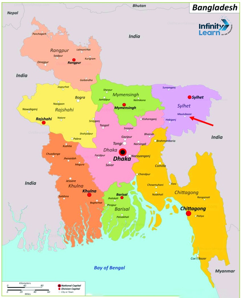
Districts of Bangladesh Map
The districts of Bangladesh can be visualized on a map, which provides a clear understanding of their geographical locations and boundaries. The map also highlights the eight divisions and their respective districts, making it easier to comprehend the administrative structure of the country.


64 Districts of Bangladesh PDF
For a comprehensive overview of the districts, a PDF document can be a valuable resource. It can include detailed information about each district, such as its area, population, major cities, and notable landmarks. The PDF can also provide statistical data and comparative analysis between districts, making it a useful tool for researchers, policymakers, and anyone interested in learning more about Bangladesh’s administrative divisions.
Districts of Bangladesh PDF Download
Bangladesh Division District List
As mentioned earlier, Bangladesh is divided into eight divisions, each comprising several districts. The divisions are:
- Barisal Division
- Chittagong Division
- Dhaka Division
- Khulna Division
- Mymensingh Division
- Rajshahi Division
- Rangpur Division
- Sylhet Division
- Each division has its own unique characteristics and contributes to the overall development of the country.
Top 10 Largest Districts in Bangladesh
- Chattogram
- Rajshahi
- Dhaka
- Khulna
- Sylhet
- Rangpur
- Barisal
- Mymensingh
- Comilla
- Bogra
These districts are among the most populous and economically significant in Bangladesh, contributing to the country’s growth and prosperity.
New Districts in Bangladesh
Over the years, Bangladesh has created new districts by splitting existing ones. This process aims to improve administrative efficiency and bring government services closer to the people. Some of the most recent districts created include Bandarban, Khagrachhari, and Rangamati, which were carved out of Chittagong District.
Coastal Districts of Bangladesh
The coastal districts of Bangladesh include:
- Bagerhat
- Bhola
- Barguna
- Chandpur
- Chattogram (Chittagong)
- Cox’s Bazar
- Feni
- Gopalganj
- Jhalokati
- Jessore
- Khulna
- Lakshmipur
- Narail
- Noakhali
- Patuakhali
- Pirojpur
- Rajshahi
- Satkhira
- Shariatpur
Districts of Bangladesh FAQs
What are the 7 districts of Bangladesh?
Bangladesh is divided into 64 districts, also known as zilas. There is no definitive list of just 7 districts, as the country has a total of 64 districts spread across 8 divisions. Some of the most well-known districts include Dhaka, Chittagong, Khulna, and Rajshahi, but Bangladesh has many more districts beyond these.
Which are the 20 districts in Bangladesh?
Bangladesh has 64 districts in total. Some of the more prominent districts include: Dhaka Chittagong Khulna Rajshahi Sylhet Barisal Rangpur Mymensingh However, there is no definitive list of just 20 districts, as the country is divided into 64 districts in total. The districts are further subdivided into 495 sub-districts called upazilas.
Which is the biggest district in Bangladesh?
The largest district in Bangladesh by area is Chittagong District, which covers 5,283.31 square kilometers. It is located in the Chittagong Division and has Chittagong City as its administrative center. Some other large districts include: Chuadanga - 1,188 sq km Dinajpur - 3,437 sq km Kurigram - 2,296 sq km Lalmonirhat - 1,241 sq km Nilphamari - 1,571 sq km Panchagarh - 1,302 sq km Thakurgaon - 1,946 sq km However, in terms of population, Dhaka District is the largest, with over 19 million residents as of 2022 estimates.
How many states are in Bangladesh?
Bangladesh is not divided into states. Instead, the country is divided into 8 administrative divisions, which are further subdivided into 64 districts (zilas). The divisions are: Barisal Chittagong Dhaka Khulna Mymensingh Rajshahi Rangpur Sylhet So in summary, Bangladesh has 8 divisions, not states. The divisions are the first-level administrative units, below which are the 64 districts.
What is the official name of Bangladesh?
The official name of Bangladesh is the People's Republic of Bangladesh
Why is Bangladesh called the People's Republic?
Bangladesh is called the People's Republic because it is a parliamentary republic where the people have a say in the government through elected representatives. The term People's Republic emphasizes that the country is governed by and for the people.
When did Bangladesh officially become the People's Republic of Bangladesh?
Bangladesh declared independence from Pakistan in 1971 after a liberation war. The current constitution establishing Bangladesh as the People's Republic was enacted on November 4, 1972 and took effect on December 16, 1972.
What does the name Bangladesh mean?
The name Bangladesh is a combination of the Bengali words Bangla (Bengal) and desh (country), meaning Country of Bengal. This reflects the cultural and linguistic identity of the Bangladeshi people.


