
Table of Contents
The Delhi Metro is a vital transportation network that connects Delhi and nearby areas. It’s a popular choice for millions of commuters due to its efficiency and comfort. The system has around 390.14 kilometers of tracks that run both above and below ground, with 286 stations, including NOIDA, Greater NOIDA, Gurugram, Corridor, and Rapid Metro.
On a daily basis, it serves roughly 4.7 million passengers. The construction of the Delhi Metro map happened in three phases. The first two phases introduced radial lines, while the third phase added a circular and a semi-circular line. Trains travel at speeds of up to 80 kilometers per hour, stopping for 20 seconds at each station.
These trains come in 4, 6, or 8-coach configurations, with a frequency of 1 to 4 minutes during peak hours and 5 to 10 minutes during non-peak times. Different lines use either broad-gauge (1676 mm) or standard-gauge (1435 mm) tracks. Some of the busiest stations on the Delhi metro route are Rajiv Chowk, Karol Bagh, and Laxmi Nagar.
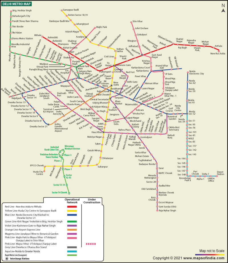
Delhi Metro Map
The Delhi Metro Map is an essential tool for navigating the extensive and efficient metro system in India’s capital city, Delhi. This comprehensive map provides a visual guide to the intricate network of metro lines, stations, and connections that serve the city and its surrounding regions.
With its user-friendly design and clear layout, the Delhi Metro Map is an invaluable resource for both residents and visitors, making it easy to plan journeys and explore the vibrant metropolis of Delhi.
Delhi Metro Map Route
The Delhi Metro is a well-organized and extensive mass transit system that provides a convenient and efficient way to explore this vibrant metropolis and its neighboring cities.
The map below is your key to understanding the various lines, stations, and connections that make up the Delhi Metro network, ensuring a smooth and enjoyable journey through this bustling urban landscape.


Delhi Metro Overview
The following table provides essential information about the Delhi Metro, a crucial mass transit system serving multiple cities in the National Capital Region of India.
| Delhi Metro Overview | |
| Owner | Delhi Metro Rail Corporation (joint-venture between Government of NCT of Delhi and Government of India) |
| Serving Cities | Delhi, Noida, Ghaziabad, Faridabad, Gurgaon, Bahadurgarh |
| Number of Lines | 11 |
| Headquarters | Metro Bhavan, Barakhamba Road |
| Started Operations in | 2002 |
| Daily Timings | 5:00 am to 11:30 pm (varies with station) |
| Fare | ₹ 10–60 |
Delhi Metro History
The Delhi Metro has completely transformed how people get around the city. It’s a safe, dependable, and eco-friendly way to travel that’s had a huge impact on easing traffic and enhancing connections for millions. Here’s a brief overview of the key milestones in the Delhi Metro’s history:
Planning and Inception (1948-1995)
The idea for a metro system in Delhi was first suggested in 1948 by the Delhi Development Authority (DDA), recognizing the need for a modern public transportation system in the quickly expanding city. It was further explored in 1969 by the Delhi Transport Corporation (DTC).
Then, in 1984, the Delhi Metro Rail Corporation (DMRC) was created as a collaboration between the Government of India and the Government of Delhi to execute the metro project. In 1995, the first phase of the project was approved, and the foundation stone was laid by Prime Minister P.V. Narasimha Rao.


Phase I Construction and Inauguration (1998-2002)
Construction for the first phase of the Delhi Metro commenced in 1998, covering a total length of 8.4 kilometers. The initial stretch, from Shahdara to Tis Hazari, was opened to the public on December 24, 2002, by Prime Minister Atal Bihari Vajpayee.
This marked the start of the Delhi Metro’s operations, providing significant relief to commuters. The first phase built a network spanning 64.75 km with 59 stations, including sections of the Red, Yellow, and Blue lines.
Phase II Expansion (2003-2011)
The second phase of expansion, beginning in 2003, aimed to extend existing lines and add new ones. This phase brought the metro to prominent parts of Delhi, like Connaught Place, Pragati Maidan, and Delhi University.
It was accomplished in stages, with the last section from Central Secretariat to Qutub Minar being inaugurated on June 3, 2010. Phase II added 123.3 km of network, 86 stations, and 10 new routes and extensions.
Phase III Expansion (2011-2017)
Phase III focused on further expanding the network and 4. improving connectivity. It included new lines and extensions, like the Magenta Line and Pink Line. The first section of Phase III, connecting Central Secretariat and Mandi House, opened on June 26, 2014.
This phase was completed in 2017, adding around 140 kilometers of new lines and making the Delhi Metro one of the largest metro networks globally.


Phase IV
Phase IV of the Delhi Metro expansion is a significant undertaking to add new lines and extensions throughout Delhi and its neighboring areas. The Government of Delhi finalized Phase IV in December 2018, encompassing a network length of 103 km and 6 lines.
This phase includes various new corridors and extensions, like Aerocity to Tughlakabad, Rithala to Narela, Janakpuri West to RK Ashram, Mukundpur to Maujpur, Majlis Park to Maujpur, Lajpat Nagar to Saket G-Block, and Tughlakabad to Terminal 1 IGI Airport. Some of these lines and stations are already operational, and the rest are set to be in service by 2024.
Delhi Metro Lines
Here is a table summarizing the Delhi Metro lines, their respective lengths, and their starting and ending points:
| Delhi Metro Lines | ||||
| Metro Line | Length (Km) | Stations | Starting Point | End Point |
| Red | 34.6 | 29 | Shaheed Sthal | Rithala |
| Yellow | 49.3 | 37 | Samaypur Badli | HUDA City Centre |
| Blue | 56.6 | 50 | Dwarka Sector 21 | Noida – Electronic City |
| Blue | 8.7 | 8 | Yamuna Bank | Vaishali |
| Green | 26.3 | 21 | Inderlok | Brigadier Hoshiyar Singh |
| 3.3 | 2 | Ashok Park Main | Kirti Nagar | |
| Violet | 46.6 | 34 | Kashmiri Gate | Raja Nahar Singh (Faridabad) |
| Orange (Airport Express) | 20 | 7 | ECC Centre | Dwarka Sector 25 – New Delhi Railway Station |
| Pink* | 57.5 | 38 | Majlis Park | Shiv Vihar |
| Magenta | 37.4 | 25 | Botanical Garden | Janakpuri West |
| Grey | 5.19 | 4 | Dwarka | Dhansa Bus Stand |
In addition to these ten lines, Delhi Metro also manages Rapid Metro Gurgaon, a route spanning from Sector 55 to Phase 3, covering a distance of 11.7 kilometers and featuring 11 stations.
Delhi Metro Facts
- Delhi Metro – India’s largest and busiest subway network with the highest number of stations.
- The DMRC (Delhi Metro Rail Corporation) is committed to eco-friendliness. They carry out rainwater harvesting along the Blue Line, contributing to water conservation.
- An environmental trailblazer, Delhi Metro was the first metro system globally to receive Carbon Credits from the United Nations. This recognition was earned for its substantial contribution to reducing greenhouse gas emissions, amounting to 6,30,000 tonnes annually.
- E. Sreedharan, the founding Managing Director of Delhi Metro, is affectionately known as the “Metro Man” for his pivotal role in its success.
- Hauz Khas, a Pink Line station, holds a unique record by being located a staggering 29 meters beneath the Earth’s surface, making it one of the deepest metro stations in the world.
- Dhaula Kuan, where the Pink and Orange Lines intersect, stands at the highest point of the Delhi Metro system, soaring 23.6 kilometers above ground.
- Phase 1 of the Delhi Metro was completed a remarkable 3 years ahead of its scheduled timeline, demonstrating its efficiency and commitment to progress.
- Furthermore, to ensure passenger safety and convenience, the metro stations are equipped with escalators featuring a ‘saree guard’ mechanism to prevent sarees and other loose clothing from getting entangled.
FAQs on Delhi Metro Map
What is the Delhi Metro?
The Delhi Metro is an extensive mass transit system that connects Delhi and its neighboring areas. It's a popular choice for commuters due to its efficiency and comfort.
How long is the Delhi Metro network?
The Delhi Metro network spans approximately 390.14 kilometers, with both above-ground and underground tracks, and it serves 286 stations, including NOIDA, Greater NOIDA, Gurugram, Corridor, and Rapid Metro.
How many passengers does the Delhi Metro serve daily?
On an average day, the Delhi Metro serves around 4.7 million passengers, making it one of the busiest metro systems in India.
How was the Delhi Metro constructed?
The Delhi Metro was constructed in three phases. The first two phases introduced radial lines, while the third phase added a circular and a semi-circular line.
What is the speed of Delhi Metro trains?
Delhi Metro trains travel at speeds of up to 80 kilometers per hour and stop for approximately 20 seconds at each station
