CBSE Class 12 Geography Sample Paper Set 20
[Time Allowed : 3 hrs.] [Max. Marks : 70]
Questions 1-7 (1 Mark), 8-13 (3 Marks), 14-20 (5 Marks), 21 and 22 (Map Question-5 Marks each)
Q.1.Define the term ‘Watershed management’.
Q.2. Which state of India has the highest rank in Human Development Index (HDI) value?
Q.3. Give an example of an ancient historical town from Bihar?
Q.4. Mention any two diseases caused by contaminated water.
Q.5. Which country has proclaimed ‘Gross National Happiness’ as the measure of country’s progress?
Q.6.The regional disparities and social disparities which developed during the colonial period is an important factor for the development .Are you agree with it.
Q.7.Name the most important inland waterway of Germany.
Q.8.Explain the main aspects of the ‘National Youth Policy’ of government of India launched in 2003.
Q.9.The Gender Related Development Index (GDI) is better than neighbouring countries. Identify the value based issues on which India is ahead.
Q.10.Give the meaning of dispersed settlement. Explain any two reasons for the development of such settlement in India.
Q.11.’Most of India’s foreign trade is carried through sea route.’ Explain the statement giving three reasons.
Q.12.Explain any three characteristics of State highways in India.
Q.13.Explain any three social and economic values which encourage us to use more and more non-conventional sources of energy.
Q.14. Definetheterm’NetSownArea’. Explain any two characteristic search of dry land farming and wetland farming.
Q.15. Define the term ‘manufacturing’. Explain any four features of small scale manufacturing.
Q.16. Write down any five perspectives of the history of international trade.
Q.17. Explain any two socio-cultural and any three environmental problems of urban settlement of the world.
Q.18. Explain any five characteristics of extensive commercial grain cultivation practised in the world.
Q.19. What is Tourism? Explain any four factor that attract tourist to a particular place in the world.
Q.20. Classify ports on the basis of their specialized functions. Write main features of each.
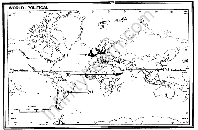
Q.21. On the given political outline map of the World, following five features are shown. Identify
these features and write their correct names on the lines marked near each feature:
(i)Areas of Dairy farming.
(ii)The country with the highest growth rate of population in Asia.
(iii)A Terminal station of Trans -Siberian railway line.
(iv)Major sea port of Pakistan.
(v)Mega city of Brazil.

Q.22. In the political outline map of India, locate and label the following with appropriate symbols:
(i)Tamil speaking state
(ii)Iron and steel Industry of Chhattisgarh
(iii) Ragi producing states
(iv)Longest Pipeline
(v)Nuclear power station of Uttar Pradesh


