Introduction: CBSE Class 12 Geography Solutions Set 3
CBSE Class 12 Geography Sample Paper With Solutions Set 3


[Time Allowed : 3 hrs.] [Max. Marks : 70]
Questions 1-7 (1 Mark), 8-13 (3 Marks), 14-20 (5 Marks), 21 and 22 (Map Question-5 Marks each)
Q.1. Name the most populous metropolitan city along with their population according to Census 2011.
Ans. Mumbai is the most populous city with its population 20.7 million as per Census 2011.
Q.2. How is the cropping intensity calculated in India?
Ans. The cropping intensity calculated in India through following formula:
Cropping Intensity = Gross Cropped Area/ Net Sown Area X 100
Q.3. Define foot-loose industries.
Ans. Footloose industry is a general term for an industry that can be placed and located at any location without effect from factors such as resources or transport. Diamonds and Computer chips are some examples of footloose industries.
Q.4. Name the two major dimensions of New Industrial Policy.
Ans. The three major dimensions of the New Industrial Policy are:
•Liberalisation
•Privatisation
•Globalisation (any two)
Q.5. Name the biggest sea-port of India.
Ans. Mumbai is the biggest sea-port of the west coast of India.
Q.6. What is meant by Crude Birth Rate (CBR)?
Ans. Crude birth rate (CBR) is the simplest and the most widely used measure of fertility. It is expressed in terms of number of births in a year per thousand of the mid-year population. It may be pointed that only live births during a year are to be taken into account. It is calculated as:
CBR = Bi/p xl00 ‘ Where,
Bi = live births during the year Population of a Particular area.
P- mid year
Q.7.Which are the two polluted stretches of river Ganga in Uttar Pradesh and Bihar?
Ans.The polluted stretches of river Ganga in Uttar Pradesh and Bihar are:
(i)Between Kanpur and Varanasi in Uttar Pradesh.
(ii)Between Patna and Katihar in Bihar.
Q.8.The people begin to understand their environment and the forces of nature with the passage of time. With social and cultural development, human develop better and more efficient technology. They move from a state of necessity to a state of freedom. They create possibilities with the resources obtained from environment. The human activities create cultural landscape. The imprints of human activities are created everywhere; arid rolling hills, ports on the coasts , oceanic routes orl the oceanic surface and satellites in the space. The earlier scholars termed this possibilism.
Read the above paragraph and analyse the following:
(i)What are the developments taking place with the passage of time?
(ii)Which thought does the above paragraph focus on, and what kind of values does it reflect?
Ans. (i) With the passage of time the human being has moved from the state of necessity to a state of freedom
(ii)The above paragraph focuses on the possibilistic thought. It shows how the social and technological developments have helped humans develop better and efficient technologies. The human have also learnt to overcome the fury of nature and it shows the confidence and lifesaving skill of the human beings.
Q.9. Singareni collieries, the country’s premier coal production company, still uses canaries to detect the presence of deadly carbon monoxide in underground mines. Why still they have faith on traditional method.
Ans. The presence of deadly gas ‘carbon monoxide’ (CO) is detected by canaries in Singareni collieries of Andhra Pradesh. As they still have faith on the traditional method but it is against the norms of environment conservation.The modern tools are to be used to detect the presence of ‘carbon monoxide’ (CO), so the wildlife can be conserved.
Q.10. Describe three kinds of shapes of age pyramids associated with three kinds of population situations.
Ans. The three kinds of shapes of population pyramid reflects the following three kinds of population situations:
•Expanding (Progressive) population: A wide base and rapid tapering shows an increasing birth rate and high death rate. Nigeria, Bangladesh, Mexico and India have expanding population structure.
•Constant (Stationary) population: A regularly tapering pyramid shows unchanging birth and death rates over a long period of time. Australia’s age pyramid is ‘bell shaped’ and tapered towards the top.
•Declining (Regressive) population: A narrow base and narrow top pyramid shows declining birth rate and low death. Japan and many developed countries have declining population.
Q.11.”Trade is the base of the world economy in the modern times”. Justify the statement with four arguments.
Ans. Trade is the base of the world economy because:
•No county in the world is self-sufficient in production . So the demand of producers in which a country is lagging, is met by the countries which have those products in surplus.
• Many developing countries which lack in industrial and technological development fulfill their demand of various technologies through imports.
• Several countries in Africa earn money by exporting large primary products. The money earned by the export of these products is spent in the development of a country. ,
Q.12. What type of rural settlements are generally found in the fertile alluvial plains of India?Mention any two features of such type of settlements.
Ans. Compact or clustered settlements are generally found in the fertile alluvial plains of India. The two main features of these settlements are:
Rural Settlement: The rural settlement consists of the houses surrounding agricultural fields. These fields are owned by the rural population. The population is mainly engaged in primary activities.
The main features of the clustered rural settlements are:
•The houses in the clustered settlements are compact.
•There are narrow winding lanes separating two rows of houses.
•Very often clustered settlements have a definite layout plan or geometric shape such as linear, rectangular, external L shaped etc.
Q.13. How do slums develop in India? Explain any four miserable conditions of the residents of slum areas.
Ans. The uninterrupted flow of immigrants to the urban areas for better job opportunities and better living standards and setting up their habitats on the government land, leads to the development of slums in India.
The four miserable conditions of the residents of slum areas are:
•Slums are devoid of the basic amenities like roads, electricity , sewerage and drinking water.
•Slums are prone to manmade hazards (fire etc.) because houses are closely placed.
•The slum workers are engaged in low paid work and high risk prone unorganized sector of the urban economy.
•The people of slums are malnourished and prone to various types of diseases and illness.
Q.14. Which is the busiest sea route in the world? Describe its four characteristics.
Ans. The North-Atlantic sea route is one of the busiest sea routes in the world, as it connects the world’s two most developed regions of the world , the eastern part of Canada and the USA to Western Europe in the west.
The four features of the North- Atlantic sea routes are:
(i)Both the coasts have good port and harbor facilities.
(ii)Foreign trade over this sea-route is greater than that of the rest of the world.
(iii)About one-fourth of the world’s foreign trade moves on this route.
(iv)Due to its business it is also called as “Big Trunk Route”. It also serves more countries and people than any other route.
Q.15. “There is low yield per acre but Righ yield per person in the interior parts of semi-arid lands of the mid latitudes in the world.” Support the statement with suitable examples.
Ans. The extensive commercial grain farming, this is mainly cultivated in the interior parts of the semi-arid lands of the mid latitude of the world. “Though in this type of farming there is low yield per acre but high yield per person” due to following reasons:
(i)The extensive commercial grain farming is a mid-latitude activity, it is all between 30° and 55° latitude in both hemispheres (temperate grasslands).
(ii)The commercial grain farming is highly specialized and mechanized .All the agricultural
activity is done by the machines. .
(iii)The farmers only concentrated on crop (grain) instead of animals and wheat is the principal crop.
(iv)The mid latitudinal areas of semi-arid regions are specializing in commercial grain, ranging from 2 to 25 people per square mile.
(v)Farms are linked to settlements by an increasing percentage of people who operate commercial grain farms but reside elsewhere than on the farms they run. Hence this farming is also stated as ‘Suitcase farming’
Q.16. Explain the factors which affect the location of rural settlements in the world.
Ans. Rural settlements are closely related to land, water supply, upland or highland, building
material and defence etc. The factors that influenced rural settlements are as follows:
(i)Water Supply: Rural settlements are located near water bodies such as river, lakes, springs and tanks, where water resource is easily accessible. Sometimes the need for water drives people to settle in otherwise disadvantage sites such as islands surrounded by swamps or low lying river banks . Water is the main basic need of human society. Hence ‘wet points’ greatly influenced rural settlements.
(ii)Land: Fertile land is a major factor for rural settlements. The rural inhabitants are mainly confined to primary activities i.e, agriculture. In southern Asia, rural settlements are highly concentrated near river valleys and coastal plains.
(iii)Upland: High elevated landmass, which are free from the common occurrence of flood. Thus main concentration of rural settlements is terraces and levees which are said to be dry points.
(iv)Building Materials: The easy availability of building materials – wood , stone near settlements is a boon. The primitive societies built their houses near forests, where wood was plentiful. Eskimos, in the polar areas use ice blocks to construct their house igloos.
(v)Defence: In earlier times, there was political instability and war hostility of neighbouring groups, villages were built on defence hills and islands. The settlement of Jaiselmer is greatly influenced by the invasion of various warrior groups.
Q.17. Define the term ‘Migration’. Explain any four factors responsible for the migration of people in India.
Ans. Migration: The movement of people from the place of origin to the place of destination.
Factors are responsible for the migration of people in India are:
•The large number of people migrate from rural areas in search of employment and better living conditions and urban areas provide ample employment in secondary, tertiary and informal sector.
•Marriage is an important social factor of migration, though this migration is female dominated. 65% of the females migrate in the rural to rural stream of migration is dominated by males, particularly in the state of Meghalaya.
•Political instability, fear of terrorism and insurgent activities also influence migration , because these factors completely disrupt the social and economic life and create an environment of insecurity. The terrorism prevailing in Jammu and Kashmir compels Hindus to migrate to the safer parts of the country.
•Natural calamities like earthquake, flood, drought, cyclones, tsunami and widespread of epidemic force the people to migrate to disaster free areas of the country for sustenance.
Q.18. Describe any five major problems of Indian agriculture.
Ans. Agriculture is the main occupation of people of India. It is the source of living for about 70% of it working population. It is the base of Indian economy. Despite its dominant role, agriculture is not been able to provide the basic need of the country. Our agriculture has failed to meet the food grains requirement of our country.
The five major problems of Indian agriculture are as follows:-
(i)Pressure of Population on Land – Due to continuous increase in population; pressure of population on land is increasing. Due to overcrowding in India has been reduces to only 0.3 hectares. It has resulted in shortage of food grains. The growth rate in agriculture is very low.
(ii)Inadequate Irrigation Facilities – In India, agriculture depends on monsoon rainfall. Due uncertain and variable rainfall irrigation is necessary. Only 22% of cultivated land is irrigated. It is necessary to irrigate at least 50% of the cultivated land to make it a success. Moreover, irrigation is required to increase the yield productivity and the intensity of cropping to check the severe draught.
(iii)Low Productivity – In India, the yield per hectare of food grains and other crop is low compared to other countries of the world. High yield verities have been introduced. But only 16% of the cultivated land is under high yield verities.
(iv)Lack of Mechanized Farming – Agriculture is mostly intensive. Human labor is used to get the maximum output. Use of modern machines is limited due the low purchasing power of farmers. The government has been taking some steps to remove the drawbacks of agriculture. A new strategy has been adapted to bring many improvement in economic, technical and organizational from of the agriculture in India.
(v)Poor Techniques of Production – Due to Continuous agriculture over a long period, the fertility of soil is declining. To maintain the fertility of the soil, the use of chemical fertilizers is necessary. Indian farmers have been using old and inefficient is low productivity. Use of better quality of seeds and pesticides can increase the productivity.
Q.19. What are the different types of environmental problems of land resource in India?
Ans. The environmental problems of land resource are risen due to wrong irrigational and agriculture development:
•The vast cultivable land in the north-western part of India is degraded due to salinisation and alkalization affected 8 million hectares of land.
•Water logging in the cultivable land adversely affects the 7 million hectares of arable land.
•The excessive intake of chemical fertilizers and pesticides made toxic to the soil profile.
•The decline of leguminous crop and more practices of multiple cropping led to the decline in regaining the natural fertility.
•In the semi-arid and arid parts of the country soil erosion is the common phenomenon by the agents of gradation i.e., wind and water, poses a serious threat to the land degradation.
Q.20. What is the importance of water transport? Describe in brief water transport system in India.
Ans. The importance of water transport is as follows:-
A.(i) Water transport is the one of the cheapest and most suitable for the transportation
of heavy and bulky goods.
(ii)No capital investment is required for its construction and maintenance cost is negligible.
(iii)Water transport is quite open even during war time.
(iv)Water transport is very low fuel efficient and less polluting.
B. (i) Water transport in India can be divided in two categories:-
•Inland Waterways
•Oceanic Waterways
(ii)India has 14, 500 km navigable water ways including canals, river, backwater and narrow bays.
(iii)3, 700 km of river suitable for mechanized craft, though only 2, 000 km of its river length is being used currently.
Q.21. On the given outline map of the World, the following five features are shown. Identify these features and write their correct names on the lines marked near each feature:
(i) Country famous for coffee plantation. (ii) A major sea-port.
(iii) A Mega city. (iv) Largest region of Dairy farming,
(v)Western terminal of Australian Trans-Continental railway.
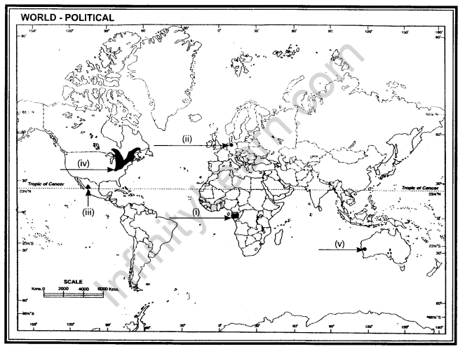
Ans. (i) Gabon (ii) Hamburg (iii) Mexico City (iv) Canada (v) Perth
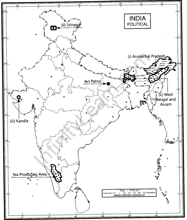
Q.22. On the given outline map of India, locate and label the following with appropriate symbols:
(i)The state having lowest density of population.
(ii)The Software Technology Park located in Jammu & Kashmir.
(iii)Sea – port located in Gujarat.
(iv)Metropolitan city of Bihar.
(v)Tea producing state
Ans.