Table of Contents
Originating from the Satpura Range in central India, the Tapti River, also known as Tapi, It’s length is approximately 724 kilometers (450 miles) until it culminates in the Arabian Sea. This significant river traverses through the Indian states of Maharashtra, Madhya Pradesh, and Gujarat, serving as a lifeline for numerous communities. It stands as one of India’s prominent rivers, alongside the likes of the Godavari and the Narmada. The Tapti River is not merely a source for irrigation and drinking water; it also serves as a vital ecosystem supporting diverse wildlife. The riverbanks are adorned with vibrant towns and verdant landscapes, contributing to its scenic beauty and significance in the Indian terrain. Additionally, the Tapti River holds considerable cultural and historical value in India, further enhancing its role as a key geographical landmark of the nation.
History of Tapti River


Historical and Mythological Connections: The Tapti River finds mention in various ancient Indian scriptures, such as the Puranas and the Mahabharata. In Hindu mythology, it’s revered as the sister of the goddess Ganga, symbolizing purity and sanctity as reflected in numerous historical and religious texts.
Settlements and Ancient Societies: Historically, the Tapti River’s shores have hosted a myriad of settlements and cultures. Its fertile lands were instrumental in nurturing early agricultural communities, positioning it as a foundational hub for human settlement in the area.
Importance in Trade: During the medieval period, the Tapti River was integral to the region’s commerce and trade. Its navigable sections served as conduits for goods, enhancing trade across central and western India.
Developments in the Colonial Period: The British colonial period marked significant development in the Tapti River area. The British capitalized on the river’s agricultural and transportation potential, building dams and canals that greatly boosted the region’s farming output.
Contemporary Significance: Presently, the Tapti River remains essential for irrigation, energy production, and as a water source for both domestic and industrial purposes. Structures like Gujarat’s Ukai Dam highlight its continued relevance in the area’s progress.
Environmental and Cultural Impact: In contemporary times, the Tapti River transcends its physical existence, symbolizing a rich cultural heritage and environmental importance. Preservation efforts for the river align with broader goals to maintain India’s natural and cultural legacies.
Tapti River Origin
The Origin of Tapti river start from Betul district in Madhya Pradesh, India, winds its way through the Khandesh plateau and Surat’s plains before joining the Arabian Sea. Tapti river length is approximately 724 kilometers and covers a drainage basin of about 30,000 square kilometers. In Hindu tradition, the river’s name ‘Tapi’ is believed to be inspired by Goddess Tapi, who is considered the daughter of Lord Surya and Goddess Chhaya.


Topography of Tapti River
The Tapti River, often referred to as the Tapi, It begins from Gawilgarh Hills located in the heartland of the Deccan plateau, specifically in the southern-central part of Madhya Pradesh. Its path takes it westward, navigating through the twin protrusions of the Satpura Range. It then traverses the plateau of Jalgaon in Maharashtra, eventually reaching the plains of Surat in Gujarat, before finally emptying into the Gulf of Khambhat, a branch of the Arabian Sea. Spanning approximately 435 miles (about 700 kilometers), the Tapti River has a catchment area of around 25,200 square miles (or 65,300 square kilometers). The river’s basin, encompassing an expanse of 65,145 square kilometers, represents close to two percent of India’s total land area, stretching across Maharashtra, Madhya Pradesh, and Gujarat.
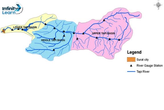
Tapti River Map
Tapti River Tributaries
The Tapti River, meandering through the heart of India, is sustained by numerous feeder streams that amplify its flow and ecological significance. These smaller rivers are vital to the Tapti’s health and to the welfare of the regions they cross. Among the noteworthy feeders of the Tapti River are:
- The Purna River: A primary feeder that joins the Tapti in Maharashtra, the Purna is key for irrigation and farming in its vicinity.
- The Girna River: This significant feeder, merging with the Tapti in Maharashtra, boasts a vast basin that underpins a variety of farming endeavors.
- The Panjhara River: It courses through Maharashtra, pouring into the Tapti and bolstering the agricultural richness of the locale.
- The Arunavati River: This river converges with the Tapti in Maharashtra, enhancing the region’s water resources.
- The Buray River: A smaller contributor, the Buray joins the Tapti in Maharashtra and is integral to the local ecological system and agriculture.
- The Gomai River: This stream also flows into the Tapti in Maharashtra, augmenting its waters.
- The Bori River: Contributing to the Tapti in Maharashtra, the Bori River is essential for meeting the water requirements of its basin.
- The Kaveri River (distinct from the larger Kaveri in South India): A minor feeder, it adds to the Tapti’s flow in Maharashtra.
These streams not only increase the Tapti River’s volume but also foster a rich biodiversity and meet the agricultural and water demands of the region. They are crucial for maintaining ecological equilibrium and the livelihoods of the populations in the areas they pass through.


Tapti River System
The Tapti River, a prominent river system in India, emerges from the Satpura Range in southern Madhya Pradesh, situated in the country’s central region. Traversing a westward path, it passes through various districts in Madhya Pradesh, Maharashtra, and Gujarat, eventually merging with the Arabian Sea close to Surat, Gujarat. This river spans approximately 724 kilometers in length and encompasses a catchment area of about 48,000 square kilometers. It plays a crucial role in agricultural irrigation and is renowned for its rich variety of fish species, such as Cirrhinus mrigala and Cyprinus carpio. As a vital geographic and ecological asset, the Tapti River significantly influences the livelihoods of communities in its path.
Key aspects of the Tapti River System include:
- Being a major waterway in the Indian peninsula, extending around 724 kilometers.
- Originating from the Satpura Range in Madhya Pradesh and flowing westward to join the Arabian Sea near Surat, Gujarat.
- Its contribution to agricultural irrigation and the sustenance of a varied fish population, underscoring its economic and ecological importance to the region.
Tapi River Basin
The Tapti River Basin, representing the second-largest basin in India that drains westward, spans a substantial portion of the country, particularly in the states of Maharashtra, Madhya Pradesh, and Gujarat. This basin covers approximately 65,145 square kilometers, accounting for about 2% of India’s total land area. Predominantly, it is situated in the northern and eastern regions of Maharashtra, encompassing districts such as Amravati, Akola, Buldhana, Washim, Jalgaon, Dhule, Nandurbar, and Nashik. Additionally, it extends into Betul and Burhanpur districts in Madhya Pradesh and the Surat and Tapi districts in Gujarat. Key tributaries feeding into the Tapti River include the Purna, Girna, Panzara, Waghur, Bori, and Aner Rivers.
Climatic conditions of Tapti River Basin
The Tapti River region experiences warm summers and is predominantly dry for most of the year, except during the southwest monsoon, particularly in the upper and middle sections of the basin. However, the lower part of the basin displays a variety in climatic conditions such as temperature, rainfall, and humidity. During the monsoon, the atmosphere becomes notably moist, and occasionally even chilly and damp, with the sky frequently obscured by dense clouds and fog for extended periods. The region receives an average annual rainfall of about 40 inches. The Tapti River flows into the Arabian Sea, which is characterized by a monsoonal climate and surface air temperatures ranging from 75 to 77 °F (24 to 25 °C). The Tapti River basin spans an area of 65,145 square kilometers, making up roughly 2.0% of India’s total land area.
Soil of the Tapti River Basin
The Tapti River Basin, stretching across central and western India, plays a important role in the region’s farming and environmental health. The basin is characterized by a diverse range of soil types, each contributing uniquely to the area’s agricultural output and environmental variety. Here is a summary of the different soil types found in the region:
- Alluvial Soil: Commonly found along the river’s edges, this nutrient-rich soil is ideal for farming. Originating from river-borne sediments, it is versatile and supports a variety of crops.
- Black Soil (Regur Soil): This soil type, prevalent in regions with volcanic rock, is particularly effective for growing cotton. Known for its ability to hold moisture, it’s a key component of the basin’s soil composition.
- Red and Yellow Soils: These soils emerge primarily where granite and gneiss rocks have eroded. Although not as fertile as alluvial or black soils, they can support certain crops, especially with appropriate cultivation techniques and fertilization.
- Laterite Soil: Developing in high-rainfall areas, laterite soil can be found in specific parts of the Tapti River Basin. It is particularly suited for growing crops like tea, coffee, and cashew nuts.
Important projects in Tapi Basin
The Tapi River Basin, important projects aimed at utilizing the river’s resources. These initiatives are integral to regional development, focusing on irrigation, electricity generation, and flood management. Here’s an overview of some major projects within the Tapi Basin:
- Ukai Dam in Gujarat: This substantial project stands out in the Tapi Basin for its multi-functional role in irrigation, flood control, and hydroelectric power production. The dam boasts a substantial reservoir, which also provides water to nearby areas.
- Girna Dam in Maharashtra: Essential for agricultural irrigation, the Girna Dam is a key player in facilitating crop cultivation in the area by supplying the necessary water resources.
- Kakrapar Dam in Gujarat: Predominantly used for irrigation and water provision, the Kakrapar Dam also contributes to flood management in its locality.
- Hatnur Dam in Maharashtra: This dam is chiefly dedicated to irrigation, playing a significant part in sustaining agricultural practices in the region through a reliable water supply.
- Gosikhurd Irrigation Project in Maharashtra: Aimed at irrigating the drought-prone Vidarbha region, this project stands as a critical irrigation endeavor.
- Sarangkheda Project in Maharashtra: Another vital irrigation project, it boosts agricultural productivity in its surrounding areas.
- Lower Tapi Irrigation Project in Gujarat: This initiative focuses on harnessing the Tapi River’s waters for irrigation, enhancing agricultural yields in the vicinity.
- Bhusawal Thermal Power Station near Maharashtra’s Tapi River: Utilizing the river water for cooling, this power station is a significant contributor to the region’s electricity supply.
Relation of Narmada and Tapti River
The Narmada and Tapi (Tapti) rivers are two major rivers in central and western India, each with its distinct geographical and cultural significance. Their relation can be understood in several aspects:
- Geographical Parallelism: Both rivers flow in a westward direction across the Indian peninsula, eventually emptying into the Arabian Sea. The Narmada originates from Amarkantak in Madhya Pradesh, while the Tapi originates from Multai in Madhya Pradesh. They run almost parallel to each other but are separated by the Satpura Range.
- The Satpura Range: This range acts as a geographical divider between the Narmada and the Tapi. The Narmada flows in a rift valley between the Vindhya and Satpura ranges, while the Tapi flows to the south of the Satpura Range.
- Tributaries and Drainage Area: While both rivers have their own network of tributaries, they cover different drainage areas. The Narmada’s major tributaries include the Hiran, the Burhner, the Banjar, and the Sher. The Tapi is joined by tributaries such as the Purna, the Girna, and the Panzara.
- Cultural and Religious Significance: The Narmada holds a special place in Hindu mythology and is considered one of the seven sacred rivers of India. Pilgrimages and religious ceremonies are common along its banks. The Tapi, though not as prominent in Hindu mythology, still holds cultural significance, especially in the regions through which it flows.
- Economic Importance: Both rivers are crucial for the regions they flow through, supporting agriculture, providing water for irrigation, and contributing to the local economies. Additionally, several large dams and hydroelectric power projects have been constructed along both rivers.
FAQs on Tapti River
Where is Tapti River?
The Tapti River is located in central India, flowing through the states of Madhya Pradesh, Maharashtra, and Gujarat before emptying into the Arabian Sea.
Are Tapti and Tapi the same river?
Yes, Tapti and Tapi refer to the same river. The name 'Tapti' is commonly used, while 'Tapi' is another name for the same river.
How did River Tapti get its name?
The River Tapti is believed to have gotten its name from Hindu mythology. It is named after the goddess Tapti, considered the daughter of Surya, the Sun God.
Does Tapti River flow in Goa?
No, the Tapti River does not flow in Goa. It flows through central India, covering Madhya Pradesh, Maharashtra, and Gujarat.
Does Tapti River form a delta?
No, the Tapti River does not form a delta. Instead, it empties into the Arabian Sea through an estuary near Surat in Gujarat.
Which river is known as Tapti?
The river known as Tapti is a significant river in central India, also referred to as the Tapi River, flowing through Madhya Pradesh, Maharashtra, and Gujarat.
What is the story behind Tapti River?
The story behind the Tapti River is rooted in Hindu mythology, where the river is personified as the goddess Tapti, the daughter of the Sun God, Surya.
Which is the twin of the Narmada River?
The Tapti River is often referred to as the twin of the Narmada River. Both rivers flow in parallel directions and have similar geological and cultural significance in central India.


