Table of Contents
Districts of Uttar Pradesh: Explore detailed insights into the 75 districts of Uttar Pradesh, covering their population statistics, historical context, cultural heritage, and administrative framework. Uncover the unique features of each district for a comprehensive view of this dynamic region.
Uttar Pradesh, India’s most densely populated state, is home to 75 distinct districts. Each Uttar Pradesh district name, including notable ones like Lucknow, Kanpur, and Varanasi, is uniquely important in the state’s diverse cultural and administrative landscape. The creation of new districts such as Prabuddhanagar, Panchsheel Nagar, and Bhimnagar in 2011 highlights UP’s commitment to adapting its administrative framework. Explore the varied demographics, history, and administrative details of each district to understand their role and significance in Uttar Pradesh.
How Many Districts in Uttar Pradesh 2025?


Uttar Pradesh, the largest state in India, spans an area of 240,928 square kilometers and was established on January 24, 1950. It is divided into 75 districts, many of which have populations exceeding 1.2 million. Each district serves as a crucial administrative unit, contributing to the state’s efficient governance and local management. For better administration, these districts are organized into 18 divisions, each with its own headquarters.
This extensive network of districts helps in effectively managing the state’s vast population and diverse needs, facilitating everything from local administration to development projects. Understanding the structure and function of these districts provides insight into the intricate administrative framework of Uttar Pradesh.
Administrative Divisions of Uttar Pradesh
Uttar Pradesh is organized into 18 administrative divisions, each with its own headquarters, serving to manage and coordinate various districts. The state, with a population of over 12 million, is home to a diverse array of communities and cultures. Below is a detailed table that highlights the administrative structure, including the number of districts and additional information about each one.
This table is an essential tool for understanding the administrative framework that governs Uttar Pradesh’s districts, providing insights into the state’s organizational structure.
| Division | Headquarters | Districts |
| Aligarh | Aligarh | Aligarh, Etah, Hathras, Kasganj |
| Agra | Agra | Agra, Mathura, Mainpuri, Firozabad |
| Azamgarh | Azamgarh | Azamgarh, Ballia, Mau |
| Ayodhya | Ayodhya | Ambedkar Nagar, Ayodhya Barabanki, Sultanpur, Amethi |
| Basti | Basti | Basti, Sant Kabir Nagar, Siddharthnagar |
| Bareilly | Bareilly | Bareilly, Pilibhit, Shahjahanpur, Badaun |
| Chitrakoot | Banda | Banda, Chitrakoot, Hamirpur, Mahoba |
| Devipatan | Gonda | Bahraich, Balrampur, Gonda, Shravasti |
| Gorakhpur | Gorakhpur | Deoria, Gorakhpur, Kushinagar, Maharajganj |
| Jhansi | Jhansi | Jalaun, Jhansi, Lalitpur |
| Kannauj | Kannauj | Auraiya, Etawah, Farrukhabad, Kannauj, Kanpur Dehat, Kanpur Nagar |
| Lucknow | Lucknow | Hardoi, Lakhimpur Kheri, Lucknow, Raebareli, Sitapur, Unnao |
| Meerut | Meerut | Baghpat, Bulandshahr, Gautam Buddha Nagar, Ghaziabad, Meerut, Hapur |
| Mirzapur | Mirzapur | Mirzapur, Sant Ravidas Nagar, Sonbhadra |
| Moradabad | Moradabad | Bijnor, Amroha, Moradabad, Rampur, Sambhal |
| Prayagraj | Prayagraj | Prayagraj, Fatehpur, Kaushambi, Pratapgarh |
| Varanasi | Varanasi | Chandauli, Ghazipur, Jaunpur, Varanasi |
| Saharanpur | Saharanpur | Muzaffarnagar, Saharanpur, Shamli |


Also Check: District of Bangladesh
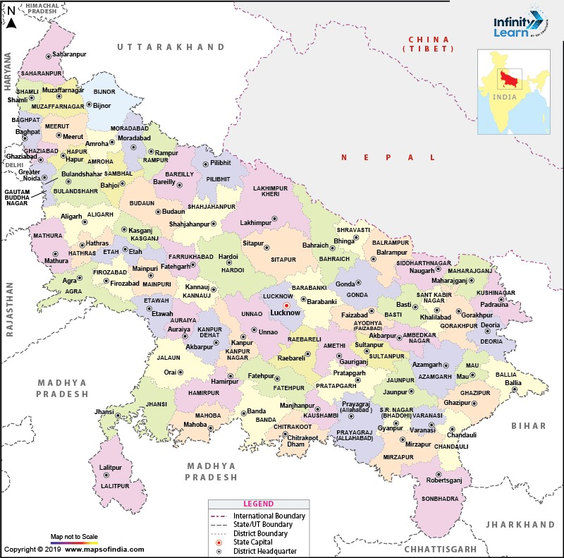
Uttar Pradesh Map with District Name
Largest District of Uttar Pradesh
- District: Lakhimpur Kheri
- Location: Northern Uttar Pradesh, along the Nepal border
- Area: 7,680 square kilometers (2,970 sq mi)
- Administrative Hub: Lakhimpur city
- Division: Lucknow
- Special Recognition: Designated as a Minority Concentrated District by the national government, indicating a need for development
- Sanitation: Ranked as the second least sanitary city in India based on a 2010 survey
- Notable Landmark: Dudhwa National Park, the only national park in Uttar Pradesh, known for its diverse wildlife, including tigers, leopards, swamp deer, and Bengal floricans


Smallest District of Uttar Pradesh
- District: Bhadohi
- Location: Northern Uttar Pradesh
- Headquarters: Gyanpur, located 45 km west of Varanasi and 82 km east of Allahabad
- Distance to Lucknow: 234 kilometers
- Nearest Airport: Lal Bahadur Shastri International Airport in Varanasi, about a 45-minute drive
- Airport Connectivity: Well-connected to major cities such as Delhi, Lucknow, and Mumbai
List of 75 Districts of Uttar Pradesh with Their Area and Population
| No. | District Name | Area (sq km) | Population |
| 1 | Agra | 4,041 | 4,418,797 |
| 2 | Aligarh | 3,788 | 3,673,889 |
| 3 | Allahabad | 5,482 | 5,954,391 |
| 4 | Ambedkar Nagar | 2,350 | 2,397,888 |
| 5 | Amethi | 2,651 | 2,050,133 |
| 6 | Amroha | 2,249 | 1,840,221 |
| 7 | Auraiya | 2,016 | 1,379,545 |
| 8 | Azamgarh | 4,054 | 4,613,913 |
| 9 | Badaun | 4,234 | 3,127,621 |
| 10 | Bagpat | 5,237 | 1,303,048 |
| 11 | Bahraich | 2,981 | 3,487,731 |
| 12 | Ballia | 3,349 | 3,239,774 |
| 13 | Balrampur | 4,408 | 2,148,665 |
| 14 | Banda | 4,402 | 1,799,410 |
| 15 | Barabanki | 4,120 | 3,260,699 |
| 16 | Bareilly | 2,688 | 4,448,359 |
| 17 | Basti | 4,561 | 2,464,464 |
| 18 | Bijnor | 4,262 | 3,682,713 |
| 19 | Bulandshahr | 4,441 | 3,499,171 |
| 20 | Chandauli | 2,541 | 1,952,756 |
| 21 | Chitrakoot | 3,216 | 991,730 |
| 22 | Deoria | 2,540 | 3,100,946 |
| 23 | Etah | 2,431 | 1,774,480 |
| 24 | Etawah | 2,311 | 1,581,810 |
| 25 | Faizabad | 2,341 | 2,470,996 |
| 26 | Farrukhabad | 2,181 | 1,885,204 |
| 27 | Fatehpur | 4,152 | 2,632,733 |
| 28 | Firozabad | 2,407 | 2,498,156 |
| 29 | Gautam Buddha Nagar | 720 | 1,648,115 |
| 30 | Ghaziabad | 1,179 | 3,343,334 |
| 31 | Ghazipur | 3,377 | 3,620,268 |
| 32 | Gonda | 4,003 | 3,433,919 |
| 33 | Gorakhpur | 3,321 | 4,440,895 |
| 34 | Hamirpur | 4,021 | 1,104,285 |
| 35 | Hapur | 649 | 1,338,311 |
| 36 | Hardoi | 5,986 | 4,092,845 |
| 37 | Hathras | 1,840 | 1,564,708 |
| 38 | Jalaun | 4,565 | 1,689,974 |
| 39 | Jaunpur | 4,038 | 4,494,204 |
| 40 | Jhansi | 5,024 | 1,998,603 |
| 41 | Kannauj | 2,093 | 1,656,616 |
| 42 | Kanpur Dehat | 3,021 | 1,796,184 |
| 43 | Kanpur Nagar | 3,155 | 4,581,268 |
| 44 | Kasganj | 1,955 | 1,436,719 |
| 45 | Kaushambi | 1,779 | 1,599,596 |
| 46 | Kushinagar | 7,680 | 4,021,243 |
| 47 | Lakhimpur Kheri | 2,905 | 3,564,544 |
| 48 | Lalitpur | 5,039 | 1,221,592 |
| 49 | Lucknow | 2,528 | 4,589,838 |
| 50 | Maharajganj | 2,952 | 2,684,703 |
| 51 | Mahoba | 3,144 | 875,958 |
| 52 | Mainpuri | 2,760 | 1,868,529 |
| 53 | Mathura | 3,340 | 2,547,184 |
| 54 | Mau | 1,713 | 2,205,968 |
| 55 | Meerut | 2,559 | 3,443,689 |
| 56 | Mirzapur | 4,405 | 2,496,970 |
| 57 | Moradabad | 2,233 | 3,126,507 |
| 58 | Muzaffarnagar | 2,742 | 2,869,934 |
| 59 | Pilibhit | 3,686 | 2,031,007 |
| 60 | Pratapgarh | 3,717 | 3,209,141 |
| 61 | Rae Bareli | 3,937 | 2,903,507 |
| 62 | Rampur | 2,367 | 2,335,819 |
| 63 | Saharanpur | 3,689 | 3,466,382 |
| 64 | Sant Kabir Nagar | 2,390 | 2,199,774 |
| 65 | Sant Ravidas Nagar | 1,646 | 1,715,183 |
| 66 | Sambhal | 1,015 | 1,578,213 |
| 67 | Shahjahanpur | 4,388 | 3,006,538 |
| 68 | Shamli | 1,266 | 1,273,578 |
| 69 | Shravasti | 1,640 | 1,117,361 |
| 70 | Siddharthnagar | 2,895 | 2,559,297 |
| 71 | Sitapur | 5,743 | 4,483,992 |
| 72 | Sonbhadra | 6,905 | 1,862,559 |
| 73 | Sultanpur | 2,457 | 2,249,036 |
| 74 | Unnao | 4,558 | 3,108,367 |
| 75 | Varanasi (Kashi) | 1,535 | 3,676,841 |
Districts of Uttar Pradesh In Hindi
| जिला नाम | जिला नाम |
| आगरा | गाज़ियाबाद |
| अलीगढ़ | गाज़ीपुर |
| इलाहाबाद | गोंडा |
| अंबेडकरनगर | गोरखपुर |
| अमेठी | हमीरपुर |
| अमरोहा | हापुड़ |
| औरैया | हरदोई |
| आज़मगढ़ | हाथरस |
| बदायूं | जालौन |
| बागपत | जौनपुर |
| बहराइच | झाँसी |
| बलिया | कानपुर देहात |
| बलरामपुर | कानपुर नगर |
| बांदा | कासगंज |
| बाराबंकी | कौशाम्बी |
| बरेली | कुशीनगर |
| बस्ती | लखीमपुर खीरी |
| बijnor | ललितपुर |
| बुलंदशहर | लखनऊ |
| चंदौली | महाराजगंज |
| चित्रकूट | महोबा |
| देवरिया | मैनपुरी |
| एटा | मथुरा |
| एटा | मऊ |
| फैजाबाद | मेरठ |
| फर्रुखाबाद | मिर्जापुर |
| फतेहपुर | मुरादाबाद |
| फिरोजाबाद | मुज़फ़्फरनगर |
| गौतम बुद्ध नगर | पीलीभीत |
| गाज़ियाबाद | प्रतापगढ़ |
| गाज़ीपुर | रायबरेली |
| गोंडा | रामपुर |
| गोरखपुर | सहारनपुर |
| हमीरपुर | संत कबीर नगर |
| हापुड़ | संत रविदास नगर |
| हरदोई | सम्भल |
| हाथरस | शाहजहाँपुर |
| जालौन | शामली |
| जौनपुर | श्रावस्ती |
| झाँसी | सिद्धार्थनगर |
| कानपुर देहात | सीतापुर |
| कानपुर नगर | सोनभद्र |
| कासगंज | सुलतानपुर |
| कौशाम्बी | उन्नाव |
| कुशीनगर | वाराणसी |
Districts of Uttar Pradesh FAQs
How many districts does Uttar Pradesh have?
Uttar Pradesh is divided into a total of 75 districts.
Which district is the largest in Uttar Pradesh by area?
Lakhimpur Kheri is the largest district in Uttar Pradesh in terms of area.
What are 25 districts in Uttar Pradesh?
Some of the districts in Uttar Pradesh include Agra, Aligarh, Allahabad, Ambedkar Nagar, Amethi, Amroha, Auraiya, Azamgarh, Badaun, Bagpat, Bahraich, Ballia, Balrampur, Banda, Barabanki, Bareilly, Basti, Bijnor, Bulandshahr, Chandauli, Chitrakoot, Deoria, Etah, Etawah, and Faizabad.
What is the name of the newest district created in Uttar Pradesh?
The most recently established district in Uttar Pradesh is Prabuddhanagar.
Which district in Uttar Pradesh is considered the biggest?
Lakhimpur Kheri is regarded as the largest district in Uttar Pradesh based on its geographical size.


