Table of Contents
Africa makes up almost one-fifth of the Earth’s total land area and is the second-largest continent (after Asia). The Atlantic Ocean borders the continent on the west, the Mediterranean Sea borders it on the north, the Red Sea and the Indian Ocean borders it on the east, and the confluence of the Atlantic and Indian oceans borders it on the south.
Also Check: Europe
The overall land area of Africa is approximately 11,724,000 square miles (30,365,000 square kilometers). It is roughly 4,600 miles (7,400 km) long from east to west and 5,000 miles (8,000 km) long from north to south. Cape Agulhas, South Africa, is its southern extremity; Xaafuun (Hafun) Point, near Cape Gwardafuy (Guardafui), Somalia, is its farthest point east; Al-Ghīrān Point, near Al-Abyaḍ Point (Cape Blanc), Tunisia, is its northern extremity; and Almadi Point (Pointe des Almadies), on Cape Verde (Cap Vert), Senegal, is its western extremity.
Before the Suez Canal was built, the Sinai Peninsula connects Africa with Asia in the northeast. Contrary to popular belief, Africa’s coastline is longer—18,950 miles or 30,500 km—than that of Europe due to the lack of significant bays, gulfs, and inlets.
Also Check: Pacific Ocean
Numerous islands off the coast of Africa are connected to the mainland. The most important of these is Madagascar, one of the world’s largest islands. Additional, smaller islands are located to the east and west, respectively, as the Cape Verde, the Bijagós Islands, Bioko, and São Tomé and Príncipe.
To the southwest are Ascension, St. Helena, and Tristan da Cunha; to the northwest are the Azores and the Madeira and Canary Islands; and to the east are the Seychelles, Socotra, and other islands.
SOUTH AFRICA


Africa’s southernmost nation is South Africa, formally known as the Republic of South Africa. Its boundaries are as follows: to the south are the South Atlantic and Indian Oceans’ 2,798 kilometers (1,739 mi) of coastline; to the north are Zimbabwe, Namibia, and Botswana, as well as their neighbors; and to the east and northeast are Mozambique and Eswatini.
Additionally, it encloses Lesotho in its entirety. It is the second most populated nation wholly south of the equator, behind Tanzania, and the southernmost nation on the Old World continent. South Africa is a hotspot for biodiversity, home to a wide variety of plant and animal species.
Also Check: Indian Ocean
The nation, which is home to approximately 62 million people, is the 23rd most populous country in the world. It is spread across 1,221,037 square kilometers (471,445 square miles).
The legislative capital of South Africa is Cape Town, which serves as the seat of Parliament. Pretoria is the administrative capital. It has long been believed that Bloemfontein is the capital of the judiciary. Johannesburg is the biggest metropolis and home to the highest court.
MAP OF AFRICA
Map of Africa: Africa is Situated on the African continental plate. Africa is the world’s second-most populous and largest continent. The equator divides the “Dark Continent” in half, and it is encircled by water everywhere where the Isthmus of Suez connects it to Asia.
To download the map of Africa, click on the link below:
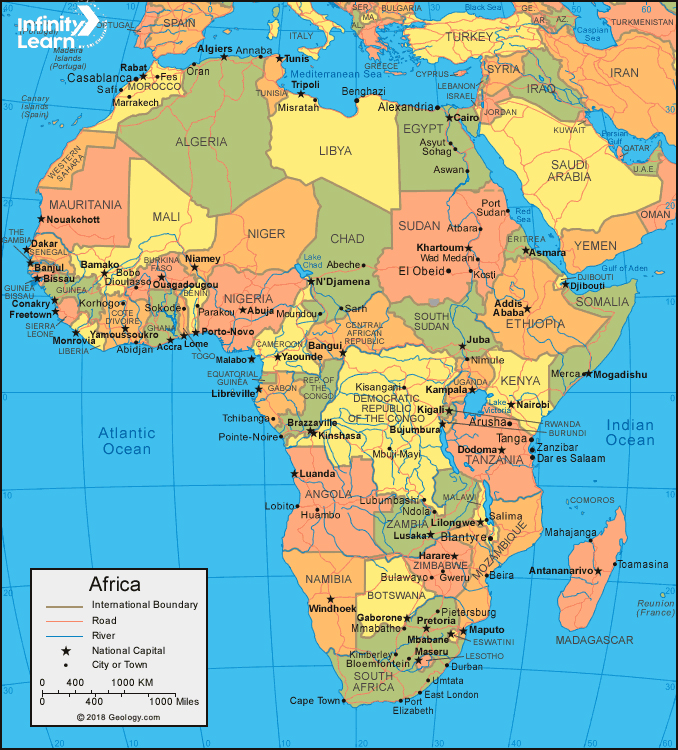
The continent’s borders are as follows: the Atlantic Ocean borders the continent’s west, the Red Sea and the Gulf of Aden its northeast, the Indian Ocean borders its south and southeast, and the Mediterranean Sea and the Strait of Gibraltar its north.


Political Map of Africa 2024
The nations of Africa and their borders are depicted on the political map of Africa. Africa is acknowledged as having 54 countries and several territories and areas.
Countries in Africa
- Kenya
- Lesotho,
- Liberia,
- Libya,
- Madagascar,
- Malawi
- Mali,
- Mauritania,
- Mauritius,
- Morocco,
- Mozambique,
- Namibia,
- Niger,
- Nigeria,
- Rwanda,
- Sao Tome and Principe,
- Senegal,
- Seychelles,
- Sierra Leone,
- Somalia,
- South Africa,
- South Sudan,
- Sudan,
- Tanzania,
- Togo,
- Tunisia,
- Uganda,
- Zambia,
- Zimbabwe
These are merely some of the many countries that make Africa their homeland.
Physical Map of Africa 2024
Physical map of Africa, which displays the continent in shaded relief.
Physical map of Africa
Tan and brown tones depict mountainous areas, such as the Kenya Highlands, the Ethiopian Highlands, and the Atlas Mountains. As you can see, the Sahara Desert region in northern Africa has nearly no rivers, whereas the Congo Basin in central Africa has a large number of them. The map displays physical features found in Africa’s Great Rift Valley, such as Lake Victoria, Lake Malawi, and Lake Tanganyika, which are situated in the southern part of the valley.


Sub Saharan Africa
Sub-Saharan Africa refers to the piece of Africa that is located south of the Sahara. These comprise West Africa, Southern Africa, East Africa, and Central Africa. According to the UN’s definition, geopolitically, the phrase may also refer to policies that only have a portion of their territory situated in that region, in addition to the African countries and territories that are entirely located in that particular region.
This region is regarded as non-standardized geographically, and the number of nations included varies from 46 to 48 depending on which entity (e.g., UN, WHO, World Bank, etc.) describes the territory. In contrast, the African Union (AU) recognizes all 55 of the continent’s member states and divides them into five distinct and standard regions.
West Africa
The westernmost part of Africa is known as West Africa or Western Africa. In addition to the United Kingdom’s overseas territories of Saint Helena, Ascension, and Tristan da Cunha, the UN defines Western Africa as the sixteen countries of Morocco, Burkina Faso, Benin, Ghana, Guinea, Guinea-Bissau, Ivory Coast, Liberia, Mali, Mauritania, Niger, Nigeria, Senegal, Sierra Leone, and Togo.
West Africa’s population was expected to be 381,981,000 in 2017 and 419 million in 2021, with 192,309,000 men and 189,672,000 women living there. On the African continent, this region is seeing some of the fastest economic and demographic growth.
Africa FAQs
What is the most visited place in Africa?
The most visited place in Africa is Morocco.
How many countries are there in Africa?
There are 54 countries in Africa.
What was Africa's original name?
The ancient name of Africa was Alkebulan.


