Table of Contents
The Kaveri River, also called the Cauvery River, is a sacred river in southern India, honored as the Goddess Kaveriamma. It’s recognized as one of India’s seven holy rivers and is widely used for farming in Karnataka and Tamil Nadu. This river begins at Talakaveri in the Western Ghats, runs for 475 miles through Karnataka and Tamil Nadu, and finally reaches the Bay of Bengal. The Kaveri River is famous for its beautiful landscapes and religious significance in Tamil literature. Its entire course is regarded as sacred land. Additionally, it plays a crucial role in irrigation canal projects and has sparked a significant water dispute between Karnataka and Tamil Nadu.
Origin of Kaveri River


Kaveri River is spread over the region of southern India. The Origin of the Kaveri river starts from the Brahmaputra Hill of Western Ghats, in Karnataka. Later, it continues to flow from the southeastern direction. The Kaveri River flows through 4 states in its 765 km journey through Karnataka, Kerala, Puducherry and Tamil Nadu. This flow moves downwards to the Eastern Ghats.
The river’s journey ends in the Bay of Bengal, south of Cuddalore, Tamil Nadu. Kaveri River breaks into small and large numbers of tributaries, forming a vast delta. This delta is named the “Garden of Southern India “. Kaveri River is necessary due to its irrigation and canal projects.
Length of Kaveri River
The total length of the Kaveri River is 805 km. Of which 320 km is in Karnataka, 416 km is in Tamil Nadu, and the remaining 64 km is a common border between Karnataka and Tamil Nadu States.


Kaveri River Map
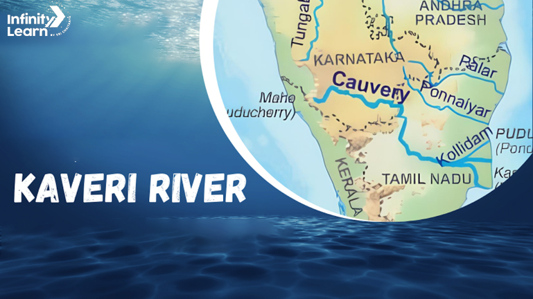
The Kaveri River starts in Talakaveri, in the Western Ghats of Karnataka. It travels almost 800 kilometers through Karnataka and Tamil Nadu. Districts like Kodagu, Mysuru, Erode, Tiruchirapalli, and Thanjavur feel its life-giving flow. It’s vital for farming. Dams like Krishna Raja Sagara and Mettur use its water. When the Kaveri meets the Bay of Bengal, it forms a rich delta. The Cauvery Wildlife Sanctuary thrives here. Along the Kaveri river map one can find many temples along the river, signifying its deep cultural value. The sharing of its water causes disputes, highlighting its environmental and socio-economic worth.
Kaveri River System
The Birthplace of Kaveri River, Talakveri, is a place in the Kadaku District in Karnataka. The Kaveri river system flows through a complicated path following the upper part of the river’s journey. The river flows through rocky paths, and its banks are covered with lush vegetation. As it continues its flow, it passes through a narrow gorge and descends around 60 to 80 feet in the rapids of Chunchanakatte.
After this, the Kaveri River widened around 275 to 365 metres and spread across the Karnataka Plateau, after entering this region, the flow of the river was slowed down by some structures called anicuts or weirs.
After reaching Krishnaraja Sagar, the Hemavati and Lakshnmantirtha tributaries join the Kaveri River. These places are dammed for irrigation, forming a 31 square km reservoir.
After entering Karnataka, the Kaveri River divides into two branches. They are known as Srirangapatna and Shivanasamudra, which are 80 km apart.
Near Shivasamudram, there is Shivasamudram Falls, which comprises two series of rapids. They are Bhar Chukki and Gangana Chukki. The falls drop from 320 feet and reach a width of 1000 feet. It usually takes place in the rainy season.
The falls are vital as they supply hydroelectric power to Mysore, Bangalore and the Kolar Gold fields from more than 160 km away.
As the river enters Tamil Nadu, the Kaveri River continues a series of twisted wild gorges before reaching Hogenakkal Falls. Later, it continues to flow through a narrow gorge at Salem. The Mettur Dam is a structure of 1,620 metres in length and 54 metres in height. It creates a large lake named Stanley Reservoir.
Moving forward, the Kaveri River flows through Tirucchchirappalli. Later, it breaks down at Srirangam Island.
The main tributaries of the Kaveri River are the Kanani, Amaravati, Motil and BhavaniRiverss.
Tributaries of Kaveri River


Hemavati River
Hemavati is one of the most important tributaries of the Kaveri River. It rises from the Western Ghats at the height of 1219 m near Ballalarayana Durga in the district of Chikmagalur in Karnataka. Later, it flows through different districts in Karnataka and joins Kaveri near Krishnarajasagara. The Hemavati River is approximately 245 km long.
Shimsha River
Another significant tributary of the Kaveri River is the Shimsha River. It originated at Devarayanadurga hills in the Tumkur district of Karnataka. Shimsha River has a waterfall that flows at Shimshapura in Malavalli Taluk.
Arkavathy River
This river is 161 km long and originates at Nandi Hills of Chikkaballapur in Karnataka. It is another tributary of the Kaveri River. It joins the Kaveri River at Kanakapura after flowing from the Kolar district and the rural district of Bangalore.
Lakshmana Tirtha
The river originated at Irupu Falls, located at Brahmagiri Range in the Kodagu district of Karnataka. Later, it continues eastward and joins the Kaveri River in the Krishna Raja Sagara Lake. Lakshmana Tirtha has Ramathirtha as its major tributary.
Kabini River
Kabini is also known as Kabani or Kapila. It’s also a tributary of the Kaveri River. It originates from the Pakramthalam hills in Wayanad district of Kerala. It has a confluence of the Panamaram River and the Mananthavady River.
Suvarnavathi River
Suvarnavathi River is 88 km long and originates from the Nasrur ghat range of Karnataka. It is also a tributary of the Kaveri River. The Suvarnavathi dam, near the Attigulapura in the village of Chamarajanagar Taluk, is also located near the Suvarnavathi river.
Noyyal River
The original name of the Noyyal River was Kanchinadi, but later, the name changed. The river originates from Velliangiri hills in the western ghats of Tamil Nadu and later drains into the Kaveri River. Noyyal River merges with the Kaveri River in the Erode district. The Noyyal River is 173 km long.
Amaravathi
The Amaravathi is also known as the Pournima River. It’s 175 km long. The river originates at the Kerala and Tamil border at the bottom of Manjampatti Valley. This valley is situated at Anamalai Hills and Palni Hills.
| Rivers of India | |
| Umngot River | Subarnarekha River |
| Kali Gandaki River Nepal | Sutlej River |
| Mahi River | Tapti River |
| Yamuna River | Widest River of India |
Kaveri River Dam
he Kaveri River Dam, also known as the Krishnaraja Sagara Dam, stands as a remarkable engineering achievement situated in the state of Karnataka, India. This monumental structure was constructed between 1911 and 1934 and marks a pioneering effort in the region as the very first major dam.
Its primary purposes are flood control in the Kaveri River and the provision of irrigation to the surrounding areas. The undertaking of constructing the Kaveri River Dam was a colossal endeavor, involving the redirection of the river’s flow and the establishment of a vast reservoir. This impressive dam was conceived by the distinguished Indian engineer, Sir M. Visvesvaraya, who also oversaw its successful completion.
The naming of the dam pays homage to Krishnaraja Wadiyar, who held the title of Maharaja of Mysore during the period when the dam was built.
Distributaries of Kaveri River
Kollidam River
Kollidam River is the northern distributary of the Kaveri River. The river is situated in southeastern India. The river flows through the delta of Thanjavur. Kollidam River splits from its main branch of the Kaveri River at Srirangam island, and later, it flows eastward and merges with the Bay of Bengal.
Vennar River
Another distributary of the Kaveri River is the Vennar River. This river flows through the Thanjavur, Thiruvarur, and Nagapattinam districts of Tamil Nadu. The river rises from Srirangam Island. At Srirangam Island, it branches off with the Kaveri River. After it diverges from Kaveri, it flows through the east, forming Vennar.
Arasalar River
The Arasalar River flows through the states of Tamil Nadu and Puducherry. It’s a distributary of the Kaveri River, which splits into five different rivers when it enters Thanjavur. The river turns from Thiruvaiyaru of Thanjavur, which branches from Kaveri and empties itself in the Bay of Bengal at Karaikal.
Kaveri River Disputes
The Kaveri River dispute between Karnataka and Tamil Nadu has been a long one. Both states argue about how much water each should get from the river. The arguments are really about farming and what each state wants. The Kaveri River issue didn’t just stay as the argument. It became legal fights too. The Cauvery Water Disputes Tribunal and the Supreme Court of India tried to help. At times, the tension between the states turned into violence. Deciding who gets the water isn’t easy. Also, the weather has been changing. So, there is less and less water to share. People have tried to solve the Kaveri River conflict, but they haven’t found a good way yet. All the states around the Kaveri River need different things, so it is hard to agree. The Kaveri River Dispute shows how difficult water sharing can be in India. Besides each state’s needs, many other things, like the economy and the environment, affect it too.
FAQs on Kaveri River
What is the Origin of the Kaveri River?
Kaveri River is spread over the region of southern India. It starts from the Brahmaputra Hill of Western Ghats, which is situated in Karnataka. Later, it continues to flow from the southeastern direction. It continues for almost 765 km through Karnataka and Tamil Nadu. This flow moves downwards to the Eastern Ghats.
Who are the distributaries of the Kaveri River?
Kollidam River is the northern distributary of the Kaveri River. The river is situated in southeastern India. The river flows through the delta of Thanjavur. Another distributary of the Kaveri River is the Vennar River. This river flows through the Thanjavur, Thiruvarur, and Nagapattinam districts of Tamil Nadu. The Arasalar River flows through the states of Tamil Nadu and Puducherry. It's a distributary of the Kaveri River, which splits into five different rivers when it enters Thanjavur. The river turns from Thiruvaiyaru of Thanjavur, which branches from Kaveri and empties itself in the Bay of Bengal at Karaikal.
How many tributaries does the Kaveri River have?
The Kaveri River has 29 major tributaries, and its main tributaries include Harangi, Hemavati, Lakshmana Tirtha, Kabini, Suvarnavathi, Shimsha, Arkavati, Sarabanga, Bhavani, Noyyal, Thirumanimutharu, and the Amaravati.
Which state owns Kaveri River?
The Kaveri River flows through two main states in India: Karnataka and Tamil Nadu. Both states share its waters, making the Kaveri River vital for both.
Which dam is on Kaveri River?
The KRS Dam, also known as Krishna Raja Sagara Dam, is a significant dam on the Kaveri River. Located near Mysore in Karnataka, it's a key source of water in the region.
Why is Kaveri River famous?
The Kaveri River is famous for its cultural and religious significance in India, along with being a lifeline for agriculture and water supply in Karnataka and Tamil Nadu.


