Table of Contents
Landforms are the different shapes and features we see on the Earth’s surface, like mountains, hills, flat areas, and lowlands. They are formed by natural actions such as wearing away, depositing materials, and shifting of the earth.
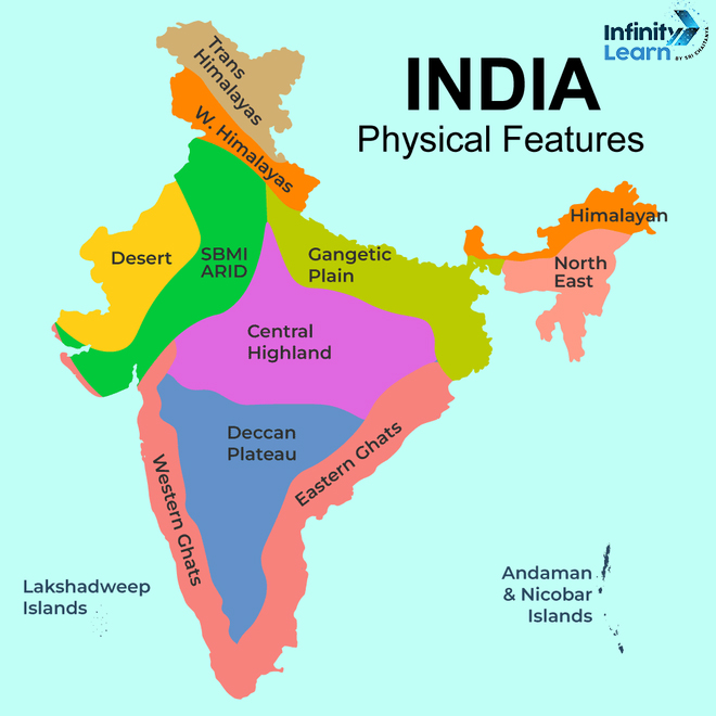
India’s landscape is a mosaic of diverse landforms, each contributing to the country’s unique geographical identity. From the towering mountains to the expansive plains, the arid Thar Desert, and the coastal peninsulas, these natural features are integral to India’s charm as a tourist destination. Notably, major landforms of India like the southern peninsula. Educational resources such as landforms of India for classes 3, 4, and 5, along with detailed maps, charts, and images with names, provide an in-depth understanding of these geographical features. This article offers a comprehensive exploration of India’s landforms, examining their significance and the various types, as illustrated in physical maps and PDF resources. The diverse landforms, from the 5 major different types of landforms of India presented with pictures, underscore India’s status as an incredible tourism hub.
Different Types of Landforms in India


- Himalayas: Spanning the northern part of India, the Himalayas cover around 612,021 sq km. This mountain range is segmented into regions including Jammu and Kashmir, the Punjab Plains, and the Ganga Plain.
- Northern Indian Plains: Extending over 700,000 sq km, these plains are shaped by the sedimentary actions of rivers originating in the Himalayas. They are known for their fertile soil.
- Great Indian Desert: Also referred to as the Thar Desert, this arid region lies in northwest India, characterized by its sandy terrain and limited vegetation.
- Peninsular Plateau: Encircled by the Aravallis, Vidhyas, and Satpuras mountain ranges, the plateau is bifurcated into the Central Highlands and the Deccan Plateau.
- Coastal Plains: India’s eastern coastal plains stretch between the Eastern Ghats and the Bay of Bengal, while the western coastal plains run between the Western Ghats and the Arabian Sea.
- Islands: India governs two major island groups: the Lakshadweep Islands and the Andaman and Nicobar Islands.
Major Landforms of India
India is a country with diverse landforms, including mountains, plains, deserts, plateaus, coastal regions, and islands. The major landforms of India are the Great Mountains, the Thar Desert, the Great Plains of North and Middle India, the Peninsular Plateau, and the Coastal Areas and Islands. The Great Mountains refer to the Himalayas, which are the world’s highest mountain range. The Thar Desert is located in the northwest of India and is characterized by its sand dunes and sparse vegetation. The Great Plains of North and Middle India are some of the most fertile lands in India and are formed due to the constant depositional motion of the Himalayan rivers. The Peninsular Plateau is surrounded by three different mountain ranges, including the Aravallis, the Vidhyas, and the Satpuras. The Coastal Areas and Islands include the eastern and western coastal plains and two main islands under Indian territory, the Lakshadweep Islands and the Andaman and Nicobar Islands.


Different Landforms of India in Detail
Himalayas
This majestic mountain range spans across India’s northern region, covering 612,021 sq km. Recognized as the highest mountain range globally, the Himalayas are segmented into three areas:
- Jammu and Kashmir
- The Punjab Plains
- The Ganga Plain
Formed by the collision of the Indian and Eurasian plates, this mountain range is a biodiversity hotspot, sheltering species like the snow leopard and red panda. The Himalayas are crucial for water supply in countries such as India, China, and Bangladesh.
Also Check: Capital of Punjab

Northern Indian Plains
Spanning over 700,000 sq km, these plains arise from the sediment deposits of Himalayan rivers. They are among India’s most fertile regions, comprising:
- The Indo-Gangetic Plain
- The Bihar and Bengal Plain
Hosting cities like Delhi and Kolkata, these plains are marked by a semi-arid climate, with hot, dry summers and cold, humid winters.


Great Indian Desert (Thar Desert)
The Great Indian Desert, also known as the Thar Desert, is located in the northwestern part of the Indian subcontinent. It covers an area of 200,000 km² in India and Pakistan, with a major part of the desert lying in Rajasthan, India. The Thar Desert experiences very hot summers and very cold nights in winter. It receives very little rainfall and is covered by shifting sand dunes.
Also Check: Rajasthani Traditional Dress
Peninsular Plateau
Encircled by the Aravallis, Vidhyas, and Satpuras, this plateau is divided into:
- The Central Highlands
- The Deccan Plateau
Characterized by varied landscapes like hills and valleys, it houses vital rivers like the Narmada and Godavari, and is rich in minerals such as iron ore and diamonds.
Coastal Plains
The Eastern Coastal Plains lie between the Eastern Ghats and the Bay of Bengal, while the Western Coastal Plains are between the Western Ghats and the Arabian Sea.
-
- The Eastern Coastal Plains: Notably thin and sprawling with lagoons and raised beaches.
- The Western Coastal Plains: Similarly slender, featuring lagoons and the picturesque Malabar Coast.
Islands
India’s territory includes two primary island groups:
- Lakshadweep Islands: North of the Maldives, these islands boast stunning beaches, coral reefs, and a rich marine ecosystem.
- Andaman and Nicobar Islands: In the Bay of Bengal, these islands are celebrated for their pristine beaches, dense forests, and unique wildlife like the Andaman Islander and Nicobar pigeon
Also Check: Culture of Andaman and Nicobar Islands
landforms of India Map
5 Landforms of India
- Himalayan Mountain Range: The Himalayas stand as the tallest mountain range globally.
- Thar Desert: This desert in northwest India is distinguished by its sandy dunes and limited vegetation.
- Fertile Plains of North and Central India: These plains, among India’s most fertile regions, are shaped by the continuous sediment deposits from rivers originating in the Himalayas.
- Peninsular Plateau: Encircled by the Aravalli, Vindhya, and Satpura mountain ranges.
- Coastal Regions and Islands: Comprising the eastern and western coastal plains, along with major islands like the Lakshadweep and the Andaman and Nicobar Islands under Indian governance.

Major Landforms of India on Physical Map
Landforms of India Chart
| Landforms of India | Features of Landforms of India |
| Himalayas |
|
| Thar Desert |
|
| Great Plains |
|
| Peninsular Plateau |
|
| Coastal Areas and Islands |
|
FAQs on Landforms of India
What are the major landforms of India?
India has five major landforms, including the Great Mountains (Himalayas), the Thar Desert, the Great Plains of North and Middle India, the Peninsular Plateau, and the Coastal Areas and Islands.
What is the major landform in the southern region of India?
The major landform in the southern region of India is the Peninsular Plateau, which is surrounded by three different mountain ranges, including the Aravallis, the Vidhyas, and the Satpuras.
How many landforms are there?
India has five major landforms, including the Great Mountains, the Thar Desert, the Great Plains of North and Middle India, the Peninsular Plateau, and the Coastal Areas and Islands.
What is the climate and landforms of India?
India has a diverse climate and landforms, including mountains, plains, deserts, plateaus, coastal regions, and islands. The climate varies from tropical in the south to temperate in the north.
What are 2 examples of landforms?
Two examples of landforms in India are the Himalayas, which are the worlds highest mountain range, and the Thar Desert, which is located in the northwest of India and is characterized by its sand dunes and sparse vegetation.


