Table of Contents
Transport And Communication Class 12 Important Questions Chapter 10


Chapter 8: Transport and Communication Important Questions for Class 12 Geography are essential for exam preparation. Access them here to excel in your Geography Class 12 studies. Students can also access CBSE Syllabus for Class 12.
1 Mark Questions
Question 1.Which country of the world has the highest road density? (All indin 2017)
Answer: Japan has the highest road density in the world.
Question 2. Why is west Asia the least developed in rail facilities? Explain one reason, (AH India 2017)
Answer: West Asia is the least developed in rail facilities because of vast deserts and sparsely populated regions.
Question 3. Define the term ‘Transport network’. (Delhi 2015)
Answer: Several places (nodes) joined together by a series of routes (links) to form a pattern is called transport network.
Question 4. In which country are motorways called ‘autobahans’? (AH Indio 2015)
Answer: Motorways are called autobahns in Germany.
Question 5. Mention the busiest ocean route of the world. (Delhi 2014)
OR
Which is the busiest sea route in the world? (All Indio 2011)
Answer: The North Atlantic sea route also called Big Trunk route is the busiest ocean route of the world.
Question 6. Name the seaports on each end of Suez Canal. (Delhi 2014)
Answer: In the North, it is Port Said in the Mediterranean sea and in the South, it is Port Suez in Red Sea.
Question 7. Define the term road density. (Delhi 2014)
Answer: Road density is defined as the total length of road per 100 sq km.
Question 8. What is the meaning of cyberspace? (All India 2014)
Answer: Cyberspace is the world of electronic computerised space. It is also called the Internet. In other words, it is the means to communicate and access information over computer networks.
Also Check: CBSE Class 12 Date Sheet 2024 Out
Question 9. Name the most important inland waterway of Germany. (AH Indio 2014)
Answer: The Rhine waterway is the most important inland waterway of Germany. This waterway is the most heavily used at the world level.
Question 10. Name the terminal stations of ‘Australian trans-continental railway.’ (Delhi 2013, 2009)
Answer: Perth and Sydney are the terminal stations of ‘Australian trans-continental railway.
Question 11. Which highway connects North America and South America? (All Indio 2013)
Answer: The Pan American highway connects the countries of South America, Central America and North America.
Question 12. Name the navigational canal that serves as a gateway of commerce for both the continents of Asia and Europe. (Delhi 2011)
Answer: The canal that serves as a gateway is the Suez Canal.
Question 13. Give the significance of river St Lawrence as an inland waterway. (Delhi 2011)
Answer: A unique commercial waterway is formed by the estuary of St Lawrence River and the Great Lakes in the Northern part of North America. The ports on this route are equipped with all facilities of ocean ports. In this way, the inland waterway has become an important commercial waterway.
Question 14. Name the terminal stations of the orient express railway. (All India 2011)
Answer: Paris and Istanbul are the two terminal stations of the orient express railway.
Question 15. Name the terminal stations of Australian Trans-continental railway. (Delhi 2009)
Answer: The terminal stations of Australian Trans-continental railway are Sydney and Perth.
Question 16. Name the terminal stations of longest railway route in the world. (All Indio 2009)
Answer: The longest railway in the world is Trans-Siberian railway and its terminal stations are Vladivostok and St Petersburg.
Question 17. Which is the famous petroleum pipeline’ of USA? (All India 2000)
Answer: The famous petroleum pipeline of USA is called Big Inch.


3 Marks Questions
Question 18. Describe any three advantages of water transport in the world. (Delhi 2013)
Answer: Advantages of water transport/oceanic routes are as follows:
- There is no need to construct ocean routes so that the cost is saved.
- Because of the less friction of water as compared to land, it is a much cheaper mode of transport.
- Compared to land and ait ocean transport is a cheaper means for carrying of bulky materials over long distances.
Question 19. Explain any three points of the economic significance of ‘Trans- Siberian railway’. (Delhi 2013)
Answer: The Trans-Siberian railway runs from St Petersburg in the West to Vladivostok on the Pacific coast in the East. It is Asia’s most important route. Economic significance of Trans-Siberian railway is as follows:
- It links the Asian region with the West European markets.
- It runs across the Ural mountains where Chita is an agro centre and Irkutsk is a fur centre.
- It has several other connecting links to . the South with other important cities of Asia.
Question 20. What is cyberspace? Describe any two advantages of the Internet. (Delhi 2013)
Answer: Cyberspace is the world of electronic digital space. In other words, it is a digital world used as a means to communicate or access information over computer networks.
Advantages of the Internet are as follows:
- The Internet has widened the economic and social space of humans through e-mail, e-commerce, e-learning and e-governance.
- Internet as a modern communication system has made the concept of the global village a reality.
Question 21. Why is the Rhine the world’s most heavily used waterway? Explain any three reasons. (Delhi 2013)
Answer: The Rhine is the world’s most heavily used waterway due to following reasons:
- It is the world’s heavily used waterway with more than 20,000 ocean-going ships and 200,000 inland vessels exchange their cargo in this route.
- Huge tonnage moves along this stretch of the waterway.
- The river Rhine is navigable for 700 km from Rotterdam in the Netherlands to Basel in Switzerland.
Question 22. Mention the famous oil pipeline in the USA. How are pipelines one of the most convenient modes of transport? (Delhi 2011)
Answer: There is a dense network of oil pipelines in the USA which run from the producing areas to consuming areas. One such famous pipeline called Big Inch carries petroleum from the oil wells of the Gulf of Mexico to the North-Eastern states.
Pipelines are one of the most convenient modes of transport as they are used extensively to transport liquids and gases such as water, petroleum, oil and natural gas. They can carry liquid and gaseous materials for a long distance without any interruption or delays. The pipelines directly link the producing areas to the consuming areas. So they are one of the most convenient modes of transport.
5 Marks Questions
Question 23. Classify means of communication on the basis of scale and quality into two categories. Explain any two characteristics of each category. (HOTS; All Indio 2017)
Answer: Communication services involve the transmission of words and messages, facts and ideas.
It means the conveyance of information from the place of origin to the place of destination through a channel. On the basis of scale and quality communication services can be divided into the following types:
Personal Communication Personal means of communication convey information between two people only. For example, postal services, telephone, telegraph and fax services, internet, etc. Its major characteristics are:
- It conveys information between two people only.
- It is a very fast and efficient way of communication.
Mass Communication Radio and television help to relay news, pictures and information to vast audiences around the world and hence, they are termed as mass media. Its major characteristics are:
- It conveys information to large audiences.
- They are vital for advertising and entertainment.
Question 24. ‘The Suez and the Panama Canal are two vital man-made navigation canals which serve as the gateways of commerce for both the Eastern and Western worlds.’ In light of this statement, explain the economic significance of these two canals. (HOTS; Delhi 2016)
OR
Name the vital man-made shipping canal linking the Mediterranean sea and the Red Sea. Write any four characteristics of this canal. (All Indio 2010)
Answer: The Suez and the Panama Canal are the two vital man-made navigation canals. Suez Canal links the Mediterranean sea and the Red Sea. It was constructed in 1869. It is the vital man-made shipping canal which acts as a linkage between the Eastern and Western world. For characteristics of Suez Canal,
Following are the main characteristics of the Suez Canal:
- Suez canal links Port Said in the North and Port Suez in the South connecting the Mediterranean sea and Red sea.
- It reduced the sea route distance between Liverpool and Colombo as compared to the Cape of Good Hope route.
- It opens a new route to the Indian Ocean for the Europeans
- It has no locks.
- It is 160 km long.
- The depth of the Suez Canal is 10 t < n deep.
Panama canal connects the Atlantic Ocean with the Pacific. It is an artificial 48-mile waterway. Following are the main Characteristics of the Panama Canal:
- Panama canal links Colon on the Atlantic Ocean to Panama in the Pacific ocean.
- It shortens the distance between New York and San Francisco by 13,000 km by sea. The distance between Western Europe and the West coast of the USA is also shortened.
- This canal is about 72 km long and involves a deep cutting for a length of 12 km.
- It has six lock systems and ships cross the different level through these lock systems.
Both the canals are economically significant as they have cut down the sea route by many thousand kilometres. The ships can now reach faster and hence more trade is possible. Though, the economic significance of the Panama canal is less than the Suez canal.
Question 25. ‘Trans- Canadian railway line is considered as the economic artery of Canada.’ Support the statement with suitable examples, (HOTS; AII India 2016)
Answer: The Trans-Canadian railway line is considered the economic artery of Canada due to the following reasons:
- This railway line covers a distance of 7,050 km running from Halifax in the East to Vancouver on the Pacific coast.
- It connects important cities of Montreal, Ottawa, Winnipeg and Calgary.
- It connects the Quebec-Montreal industrial region with the wheat belt of the Prairie region, thus gaining economic significance.
- This line also connects the coniferous forest region in the North to Quebec-Montreal and the Prairies. All these regions have become complementary to each other.
- A loop line from Winnipeg to Thunder Bay (Lake Superior) connects this rail line with one of the important waterways in the world.
Question 26. “The Rhine waterways is the world’s most heavily used island waterway”. “In the light of this statement, examine the significance of the waterway. (HOTS; All Indio 2016)
Answer: Rhine waterways are significant in the following ways:
- It is the world’s heavily used waterway with more than 20,000 ocean-going ships and 200,0 inland vessels exchange their cargo in this route.
- Huge tonnage moves along this stretch of the waterway.
- The river Rhine is navigable for 700 km from Rotterdam in the Netherlands to Basel in Switzerland.
- It flows through a rich coalfield which has made the whole region prosperous manufacturing area.
- The waterway links the industrial areas of Germany, France, Switzerland, Belgium, the Netherlands with North Atlantic sea routes.
Related Links
- CBSE Class 12 Physics Syllabus
- CBSE Class 12 Math Syllabus
- CBSE Class 12 Chemistry Syllabus
- CBSE Class 12 Biology Syllabus
- CBSE Class 12 Hindi Syllabus
- CBSE Class 12 Computer Science Syllabus
Question 27. Explain the importance of ‘communication services’ in the world. (All India 2016)
Answer: The importance of communication services in the world is a follows:
- Communication connects the people living in different parts of the world, due to which trade is possible.
- Communication through Optic Fibre Cables allows large quantities of data to be transmitted rapidly, securely and are virtually error-free.
- Communication through satellites has connected around 1000 million people in more than 100 countries.
- Cyberspace or the Internet is the latest technology for accessing information over computer networks.
- New technologies have connected people and it is very easy to send or receive messages, information. This has made the concept of the global village a reality.
Question 28. Which means of transport is extensively used for carrying water, petroleum, natural gas and other liquids? Describe the network of this means of transport in the world. (Delhi 2015)
Answer: The means of transport used extensively for carrying water, petroleum, natural gas and other liquids is pipeline transport. There is a dense network of pipelines in the USA which runs from the producing areas to the consuming areas. One such famous pipeline is Big Inch.
Pipelines are used extensively to connect oil wells to pots and the refineries or domestic markets. The longest proposed international oil and natural gas pipeline’ will pass through Iran, India and Pakistan.
In New Zealand, milk is being supplied through pipelines from farms to factories. In Europe, Russia and West Asia, oil wells are linked to refineries through pipelines. Turkmenistan in Central Asia has extended pipelines to Iran and also to parts of India.
Question 29. Describe the journey of development of land transport from the days of humans as carriers and the cableways of today, (HOTS; Delhi 2015)
Answer: Land transport refers to the movement of goods and services that takes place overland by way of road or rails.
In earlier days, humans themselves were carriers. People were carried on palanquin (palki/doli). Later animals were used as beasts of burden as on mules, horses and camels. With the invention of the wheel, carts and wagons were made that facilitated land transport.
The revolution in transport came about only after the invention of the steam engine. The first railway line was started in 1825 in Northern England and railways became the most popular and fastest mode of transportation.
The invention of the internal combustion engine revolutionised road transport in terms of road quality and vehicles playing over them. Among the newer development inland transportation are pipelines, ropeways and cableways.
Question 30. Name the longest Trans-Continental railway in the world. Describe its any four features. (Delhi 2015)
Answer: The longest Trans-Continental railway of the world is Trans-Siberian railway.
Four features of Trans-Siberian railways are as follows:
- The Trans-Siberian railways run form St Petersburg in the West to Vladivostok on the Pacific coast in the East. It is Asia’s most important route.
- It links the Asian region with the West European market.
- It runs across the Ural mountains where Chita is an agro centre and Irkutsk, a fur centre.
- There are several connecting links to the South.
Question 31. Which shipping canal links the Atlantic ocean and the Pacific ocean? Explain its any four characteristics. (All Indio 2015)
Answer: The canal that links the Atlantic and Pacific ocean is the Panama Canal. For the characteristics of the Panama Canal
The Suez and the Panama Canal are the two vital man-made navigation canals. Suez Canal links the Mediterranean sea and the Red Sea. It was constructed in 1869. It is the vital man-made shipping canal which acts as a linkage between the Eastern and Western world. For characteristics of Suez Canal,
Following are the main characteristics of the Suez Canal:
- Suez canal links Port Said in the North and Port Suez in the South connecting the Mediterranean sea and Red sea.
- It reduced the sea route distance between Liverpool and Colombo as compared to the Cape of Good Hope route.
- It opens a new route to the Indian Ocean for the Europeans
- It has no locks.
- It is 160 km long.
- The depth of the Suez Canal is 10 t < n deep.
Panama canal connects the Atlantic Ocean with the Pacific. It is an artificial 48-mile waterway. Following are the main Characteristics of the Panama Canal:
- Panama canal links Colon on the Atlantic ocean to Panama in the Pacific ocean.
- It shortens the distance between New York and San Francisco by 13,000 km by sea. The distance between Western Europe and the West coast of the USA is also shortened.
- This canal is about 72 km long and involves a deep cutting for a length of 12 km.
- It has six lock systems and ships cross the different level through these lock systems.
Both the canals are economically significant as they have cut down the sea route by many thousand kilometres. The ships can now reach faster and hence more trade is possible. Though, the economic significance of the Panama canal is less than the Suez canal.
Question 32.
What is the importance of railways as a mode of land transport? Explain any four main features of the railway network in Europe. (All India 2015)
OR
Explain any five characteristics of rail transport in Europe. (All Indio 2012 )
Answer: Railways cover long distances and they are ideal for the transportation of bulky goods. A large number of people also travel by railways. They also form the connecting link between the ocean vessels, barges, boats, motor trucks and pipelines.
Following are the characteristics of rail transport in Europe:
- Most of the railways in Europe is double or multiple tracked.
- The total length of railway line in Europe is 440,0 km.
- Belgium has the highest railway density of 1 km of a railway for every 6.5 sq km area.
- In many countries of Europe, passenger transport is more important than freight.
- After the development of a more flexible system of roadways and airways. The trans-continental railway line has become less important.
Question 33. Which is the longest trans-continental railway in North America? Describe its any four features. (AH India 2015)
Answer: The longest trans-continental railway of North America is Trans-Canadian railway.
For the features of Trans-Canadian railway,
The Trans-Canadian railway line is considered the economic artery of Canada due to the following reasons:
- This railway line covers a distance of 7,050 km running from Halifax in the East to Vancouver on the Pacific coast.
- It connects important cities of Montreal, Ottawa, Winnipeg and Calgary.
- It connects the Quebec-Montreal industrial region with the wheat belt of the Prairie region, thus gaining economic significance.
- This line also connects the coniferous forest region in the North to Quebec-Montreal and the Prairies. All these regions have become complementary to each other.
- A loop line from Winnipeg to Thunder Bay (Lake Superior) connects this rail line with one of the important waterways in the world.
Question 34. State any three characteristics of water transport. Why is traffic far less on the Cape of Good Hope route? (Delhi 2012)
Answer: Three characteristics of water transport are as follows:
- Water transportation does not require route construction. The oceans are linked with each other and offer smooth routes travelable in all directions with fewer maintenance costs.
- It is a cheaper means of transportation because the friction of water is less than that of the land and energy cost is lower.
- Very heavy cargo like coal, cement, timber and metallic ores can be transported through inland waterways.
The reasons for the less traffic on the Cape of Good Hope route are as follows:
- There are limited development and population in South America and Africa, so demand is less.
- Both South America and Africa have similar products and resources.
- Large scale industries are only present in South-Eastern Brazil and Plata estuary.
- There is little traffic on the route which links Rio-de Janeiro and Cape Town.
Question 35. Which continent has the highest road density? Why do traffic congestions occur on road? Explain any three measures to solve the problem of traffic congestion. (Delhi 2012)
Answer: North America has the highest road density. About 33% of the world’s total motorable road length is present in North America. North America also accounts for the highest number of vehicles as compared to Europe.
There is a problem of chronic traffic congestion in most of the cities of the world. The congestion occurs because of the failure of the road networks in meeting the demands of traffic. In recent years, the traffic on roads has substantially increased. We can see peaks and troughs of traffic flow on roads at different times of the day.
The measures to solve the problem of traffic congestion are as follows:
- The parking fee should be high.
- Mass Rapid Transit (MRT) system should be developed.
- The public bus services should be improved.
- Expressways should be developed to facilitate smooth traffic flow.
Question 36. Explain the merits and demerits of road transport in the world. (All Indio 2012)
Answer: Merits of road transport are:
- It is the most economical mode for short distances as compared to railways.
- It offers door-to-door services.
- It is best suited for the transportation of perishable and breakable goods.
- Construction of the road is comparatively cheaper and easy.
- In road transport, it is very easy to monitor vehicles and goods.
Following are the demerits of road transport:
- Road transport is not sustainable in all seasons.
- Unmetalled roads become unmotorable during the rainy season. Metalled ones are also damaged by floods.
- Road construction is very difficult in mountainous or desert areas.
- The maintenance of roads requires heavy expenditure.
- Goods are susceptible to damage through careless driving.
- Transport is subject to traffic delay in the case of road transport.
Question 37. Explain the significance of each of the transport and communication services available in the world. (Delhi 2010)
Answer: Significance of various transport services are as follows:
- Road Transport It is a cheaper and faster mode of transport over short distances and for door-to-door services.
- Railways It is best suited for bulky goods and passengers for long distances.
- Water Transport It is the cheapest mode of transport because of less friction of water. Ocean routes are cheaper for carrying of bulky material from one continent to another.
- Air Transport is the fastest means of transportation. It is best suited for long distance travel and worldwide transportation of valuable cargo.
- Pipelines It is used to carry liquids and gases from the producing areas to the consuming areas.
Significance of various communication services are as follows: - Satellite Communication In contemporary time, satellites communication has become very important with the Internet as the largest electronic network on the planet connecting about 1000 million people in more than 100 countries.
- Cyber Space-Internet This electronic network has spread unprecedently the number of users from 400 million in AD 2000 to over two billion in 2010. It has brought people from different parts of the world closer to each other.
Question 38. Name the principal mode of transportation in the world which is used for carrying liquid and gaseous materials only. Mention any four characteristics of this mode of transportation. (Delhi Board 2010)
Answer: The principal mode used for carrying liquid and gaseous material is pipeline transport. For the characteristics of a pipeline,
The means of transport used extensively for carrying water, petroleum, natural gas and other liquids is pipeline transport. There is a dense network of pipelines in the USA which runs from the producing areas to the consuming areas. One such famous pipeline is Big Inch.
Pipelines are used extensively to connect oil wells to pots and the refineries or domestic markets. The longest proposed international oil and natural gas pipeline’ will pass through Iran, India and Pakistan.
In New Zealand, milk is being supplied through pipelines from farms to factories. In Europe, Russia and West Asia, oil wells are linked to refineries through pipelines. Turkmenistan in Central Asia has extended pipelines to Iran and also to parts of India.
Question 39. What is the significance of inland waterways? Explain the three factors responsible for the development of inland waterways in the world. (All India 2010)
Answer: Inland waterways consist of rivers, lakes, canals and streams linking the coastal areas. They have been used as waterways from time immemorial. Inland waterways are important for domestic and international transport and trade. Many rivers are modified to make inland waterways possible in different developed countries. The significance of inland waterways has been rising.
The three factors responsible for the development of inland waterways in the world are:
- Navigability This means the width and depth of the channel that makes navigation possible.
- Water Flow Another factor is the continuous flow of water throughout the year so that ships, boats can easily move in the waterways.
- Transport Technology Development of proper technology so that very heavy cargo like coal, timber, metallic ores can also be easily transported through inland waterways.
Question 40. What are the highways? Explain the significance of highways with examples from different continents, (AH Indio 2009)
Answer: Highways are metalled roads constructed for uninterrupted vehicular movement. Highways link even city and port town in developed countries. The significance of highways can be explained through the following examples:
- North America Highways link the cities located on the Pacific coast with those of the Atlantic coast. Highway density is very high in North America, about 0.65 km per sq km. The Pan-American Highway connects the countries of, South America, Central America and USA.
- Europe In Europe, there is a well-developed network of highways, but faces competition from railways and waterways.
- Russia In Russia, important industrial regions are linked through highways. The Moscow-Vladivostok highway serves the region and it is one of the important highways of Russia.
- China All the major cities in China are linked through the highways.
- India In India, highways are connecting the major towns and cities. NH7 is the longest in the country which connects Varanasi and Kanyakumari.
- Africa In Africa, Algiers in the North is connected to Conakry in Guinea and Cairo is connected to Capetown through highways.
Question 41. What is the importance of roads? Explain any three reasons for the existence of good quality roads in the developed countries. (All Indio 2009)
Answer: Roads are an integral part of the transport system of a country. They play a significant role in achieving national development and contributing to the overall performance and social functioning of the community.
Freight transport by road is gaining importance because it offers door-to-door service. Road plays a very important role in the socio-economic development of the country and becomes the backbone of strong economies and dynamic societies.
Therefore, it is legitimate and indispensable to safeguard industry and plays a crucial role in everyone’s life by meeting the demand for the sustainable mobility of both people and goods.
The reasons for the existence of good quality roads in the developed countries are as follows:
- Road construction and its maintenance require heavy expenditure. The developed countries have resources to meet this kind of expenditure.
- Developed countries need good quality roads due to their constant requirement of linking long-distance transportation in the form of motorways, autobahns, interstate highways, etc.
- There is greater intensity and need for speedy movement of vehicular traffic.
Question 42. Write any six characteristics of the Suez Canal. (Delhi 2009)
Answer: Following are the main characteristics of the Suez Canal:
- Suez canal links Port Said in the North and Port Suez in the South connecting the Mediterranean sea and Red sea.
- It reduced the sea route distance between Liverpool and Colombo as compared to the Cape of Good Hope route.
- It opens a new route to the Indian Ocean for the Europeans
- It has no locks.
- It is 160 km long.
- The depth of the Suez the Canal is 10 t < n deep.
Question 43. Mention any six advantages of oceanic routes. (Delhi 2009)
Answer: Advantages of water transport/oceanic routes are as follows:
- There is no need to construct ocean routes so the cost is saved.
- Because of the less friction of water as compared to land, it is a much cheaper mode of transport.
- Compared to land and air, ocean transport is a cheaper means for carrying of bulky materials over long distances.
- It does not require maintenance.
- Oceans are linked with each other and the ship and cargo of various sizes can easily traversable in all directions.
More Resources for Class 12
- NCERT Solutions for Class 12 Maths
- NCERT Solutions for Class 12 Physics
- NCERT Solutions for Class 12 Chemistry
- NCERT Solutions for Class 12 Biology
- NCERT Books
- NCERT Books for Class 12
Question 44. Which is the busiest sea route in the world? Describe its four characteristics. (Delhi 2008)
Answer: The Northern Atlantic sea route or Big Trunk route is the busiest sea route in the world. Four important characteristics of this route are as follows:
- It connects the two industrially developed regions of the world which are the North-Eastern USA and North-Western Europe.
- It accounts for one-fourth of the world’s foreign trade.
- Ports on this route are highly advanced and equipped with modern facilities.
- This route exhibits highly advanced ports and harbour facilities.
Question 45. Define the term ‘Trans-Continental railways.’ Write four characteristics each of Trans-Siberian railways and Trans-Canadian railways. (Delhi 2008)
Answer: Trans-continental railways connect the two ends of a continent while running across it. For the features of Trans-Siberian railway, The longest Trans-Continental railway of the world is Trans-Siberian railway.
Four features of Trans-Siberian railways are as follows:
- The Trans-Siberian railways run form St Petersburg in the West to Vladivostok on the Pacific coast in the East. It is Asia’s most important route.
- It links the Asian region with the West European market.
- It runs across the Ural mountains where Chita is an agro centre and Irkutsk, a fur centre.
- There are several connecting links to the South.
For the features of Trans-Canadian railways, The Trans-Canadian railway line is considered the economic artery of Canada due to the following reasons:
- This railway line covers a distance of 7,050 km running from Halifax in the East to Vancouver on the Pacific coast.
- It connects important cities of Montreal, Ottawa, Winnipeg and Calgary.
- It connects the Quebec-Montreal industrial region with the wheat belt of the Prairie region, thus gaining economic significance.
- This line also connects the coniferous forest region in the North to Quebec-Montreal and the Prairies. All these regions have become complementary to each other.
- A loop line from Winnipeg to Thunder Bay (Lake Superior) connects this rail line with one of the important waterways in the world.
Question 46. Define the term ‘transport’. Describe any four features of highways of North America. (Delhi 2008)
Answer: Transport is a service or facility for the carriage of persons and goods from one place to the other using different modes. Four features of highways of North America are as follows:
- There is a high density of highways in North America.
- Every place in North America is within a distance of 20 km.
- Cities located on the Pacific coast (West) are well connected with those of the Atlantic coast (East).
- Likewise, the cities of Canada in the North are linked with those of Mexico in the South.
Map-Based Questions
Question 47. Study the map given below carefully and answer the questions that follow.
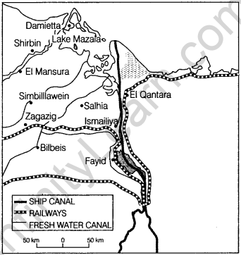
(i) Identify and name the canal shown in the map.
(ii) Write any four characteristics of this canal.
Answer:
(i) This map shows the Panama canal.
(ii) Four characteristics of this canal are:
- This connects the Atlantic ocean with the Pacific ocean.
- The canal cuts across the Isthmus of Panama and is a key conduit for international maritime trade.
- It is an artificial 48-mile waterway.
- It reduces the time for ships to travel between the Atlantic and Pacific ocean.
Question 48. Study the map and answer the questions that follow. (All iIndio2014)
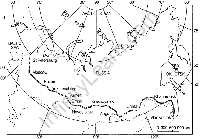
(i) Identify and name the railway line shown on the map.
(ii) Name the continents linked by this rail route.
(iii) Explain how this railway line is helpful for the promotion of trade in this region?
Answer:
(i) Trans-Siberian railway line is shown on the map.
(ii) It connects Asia and Europe.
(iii) This railway line runs across the Ural mountain and connects agro centres like Chita and Irkutsk. It also acts as a linkage between different manufacturing centres.
Question 49. Study the map and answer the questions that follow. (Delhi 2014)
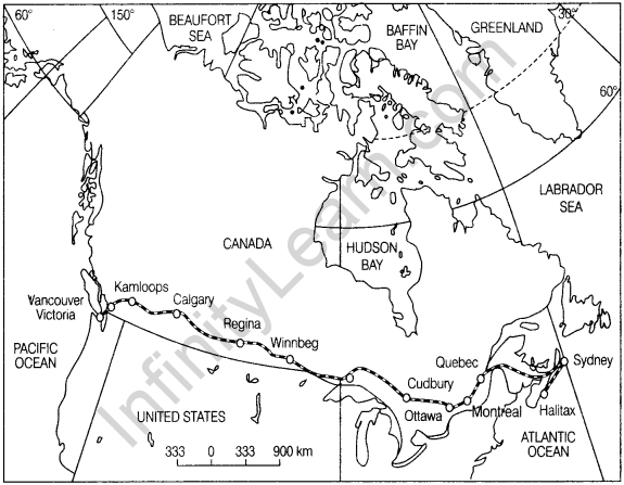
(i) Name the railway line shown on this map.
(ii) Name the terminal station of this railway along the Atlantic coast.
(iii) Why is this railway line known as the economic artery of the country through which it passes?
OR
(i) Name the Trans-continental railway shown on the map.
(ii) Name the terminal stations of this railway line.
(ii) Mention any two characteristics of this railway line.
Answer:
(i) Trans-Canadian railway line is shown on this map.
(ii) Halifax is the terminal station of this railway along the Atlantic coast.
(iii) It connects the Quebec-Montreal Industrial region with the wheat belt of the Prairie region and the Coniferous forest regions in the North. A loop line from Winnipeg to Thunder Bay connects this line with one of the important waterways. That’s
why is it called economic artery of Canada.
OR
(i) It is the Trans-Canadian railway.
(ii) Halifax and Vancouver are the terminal stations of this railway line
(iii) Two characteristics of this railway line are:
- It is 7050 km long rail line in Canada.
- It connects the industrial region to a wheat belt.
Question 50. Study the given map and answer the questions that follow, ail (India 2011)
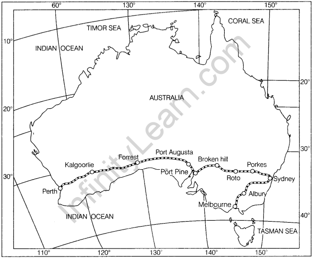
(i) Name the railway line shown in the given map.
(ii) Which are the two terminal stations of this railway line?
(iii) Name the ports located on the coast of Spencer Gulf through which this railway line passes, AH India 2009
Answer:
(i) Australian Trans-Continental railway line is shown in the given map.
(ii) Perth and Sydney are two terminal stations of Australian Trans-Continental railway line.
(iii) Port Augusta and Port Pine are two ports located on the coast of the Spencer Gulf through which this railway line passes.
Question 51. Study the given map and answer the questions that follow. (All India 2009)
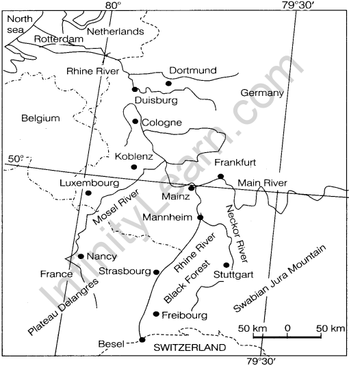
(i) Name the inland waterway shown in the given map.
(ii) How has this inland waterway been a boon in the development of the countries through which it passes? Explain.
Answer:
(i) The Rhine waterway is shown in the given map.
(ii) It is a boon in the development of the countries through which it passes because of the following reasons:
- It flows through Germany and the Netherlands.
- It is navigable up to 700 km.
- It flows through a rich coalfield and makes the white basin prosperous manufacturing area.
Question 52. Study the map and answer the questions that follow. (All India 2008)
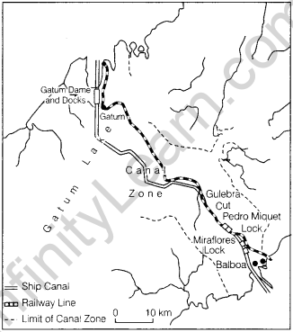
(i) Name the shipping canal shown in the map.
(ii) Name the oceans linked by this canal.
(iii) Name the country which has constructed this canal.
(iv) Why is this canal mostly used by the USA?
(v) Why does this canal have a lock system?
Answer:
(i) The canal shown in the map is the Panama Canal.
(ii) The oceans linked by this canal are the Atlantic ocean and the Pacific ocean.
(iii) The United States of America has constructed the Panama canal.
(iv) This canal is constructed by the US Government to shorten the distance between New York and San Francisco which is 12,000 km apart by sea.
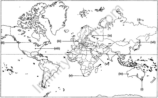
(v) The canal is at a higher elevation from sea level and it is made across mountain ranges.
Question 53. Identify the following on the political map of the world.
(i) A major seaport. (All India 2016)
(ii) An international airport. (All Indio 2016)
(iii) A major seaport. (Delhi 2016,2013,2011,2008)
(iv) An international airport. (Delhi 2016)
(v) A major seaport. (All India 2015)
(vi) A major airport. (All Indio 2015, Delhi 2013)
(vii) An important airport. (Delhi 2015)
(viii) A major seaport. (Delhi 2015,2014.2012)
(ix) A major railway terminal. (All India 2015)
Answer:
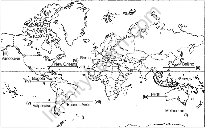
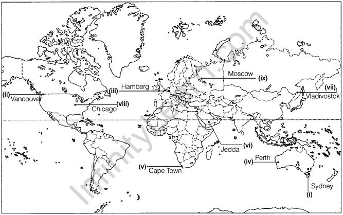
Question 54. Identify the following in the political map of the world.
(i) Railway terminal station. (Delhi 2015)
(ii) A terminal station of Trans-Canadian railway line, (AH India 2014)
(iii) An important seaport, (AH India 2014)
(iv) A terminal station of Australian Trans-continental railway. (Delhi 2014)
(v) A major seaport. (Delhi 2013. All India 2011.2010)
(vi) A major airport. (Delhi Board 2013)
(vii) Eastern Terminal station of Trans-Siberian railway. (All India 2012)
(viii) A major airport. (All Indio 2011)
(ix) A major airport. (All India 2010)
Answer:
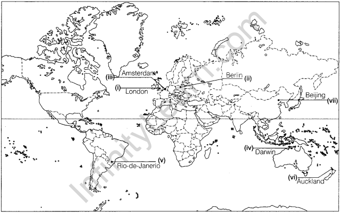
Question 55. Identify the following on the political map of the world,
(i) A major airport. (Delhi 2012)
(ii) A major seaport. (Delhi 2011)
(iii) A major seaport. (Delhi 2010)
(iv) A major airport. (Delhi 2010, All India 2008)
(v) The important seaport of Brazil, (AH India 2009)
OR
An important seaport. (All India 200a)
(vi) The important seaport of New Zealand. (Delhi 2009)
(vii) Major airport. (Delhi 2008)

Answer:


Value Based Questions
Question 56. “The means of transport are used for inter-regional and intra-regional transport, and each one (except pipelines) carries both passengers and freight. The significance of a mode depends on the type of goods and services to be transported, the costs of transport and the mode available. International movement of goods is handled by ocean freighters. Road transport is cheaper and faster over short distances and for door-to-door services. Railways are most suited for large volumes of bulk materials over long distances within a country.”
(i) Which mode of transport is suitable for Large volumes of bulky materials?
(ii) Which value can be learnt from the passage?
Answer:
(i) Railways are most suited for large volumes of bulk materials over long distances.
(ii) Values like Global peace, Economic welfare, Social awareness and Globalisation can be learnt from the above passage.
Question 57. “Horses are used as a draught animal even in the Western countries. Dogs and reindeer are used in North America, North Europe and Siberia to draw sledges over snow-covered ground. Mules are preferred in the mountainous regions; while camels are used for caravan movement in deserts. In India, bullocks are used for pulling cans
(i) Which values can be learnt from this passage?
Answer: Following values can be learnt from this passage:
- Human-Animal relationship.
- Co-existence with Environment.
- Nature-Human relationship.
We hope the Geography Class 12 Important Questions Chapter 8 Transport and Communication help you. If you have any query regarding Geography Class 12 Important Questions Chapter 8 Transport and Communication, drop a comment below and we will get back to you at the earliest.


